Cave Creek: South Fork, Horseshoe Ridge, Sentinel Peak
Coronado National Forest
Click for map.
(Day 1 of 2) By my estimate, it would be 20 miles to go up to Chiricahua Peak and also go for the Chiricahua benchmark on Flys Peak in a tidy little loop going up Basin Trail to Snowshed and down Greenhouse Trail. This could be done, but I'm not quite feeling like a 20 mile day and there are some more things along the way that might be fun to hit. Of course, just hitting the peak via the shorter of the routes (probably Greenhouse) would bring it down, but then there is even more I am missing out on. But then I found an overnight kitty sitter, which opened up some options. In fact, if I could get a ride over to South Fork, that would let me go up Sentinel and Finnicum Peaks, estimated 18 mile round trip on a loop, as well. Then I noticed at 4AM that I better get going today because the kitty sitting offer wouldn't last forever and Wednesday has a 10% chance of rain to make it a bit dreary as a hiking day. So, finally packed a few hours later than desired, I am at South Fork with some climbing to do and somewhat less research on the state of the trails and various springs around the halfway mark than is desirable. Both are a little worrying since these trails have burned recently and it is a desert.

Parking for South Fork is almost a mile short of where it shows on the map because the rest of the road got washed out and they truncated it. There is no camping and restrictions against recording and it all makes me feel generally like if I tried to leave a car here overnight, I would come back to a ticket, so I'm glad I'm not. Hopefully they don't notice me recording images and a GPS track. (Apparently the "no recording" is for video and audio and includes no playback of bird song.) Trail climbs over the side of the tall berm that ends the road now, then drops back down on the rocky remnants of road on the far side. There are a few creek crossings along the way to the end, where the vestiges of South Fork Campground have been removed, and where a second trail sign, this one with destinations, followed by a wilderness sign signal the closing in of the trees.


The first bird of the season of some particularly desirable species for the birders who come here was spotted in the canyon yesterday so today there are little knots of birders all over the place. One group ahead of me has just spotted a flutter of red and since I don't want to bustle them greatly as they just get started looking, I pause a moment. Even though I am clearly a different sort of trail user, they happily point out their new find for me. It is a pretty little bit of red flitting among the twigs. The prize is also a red bird with a bit of a cardinal shape to it, I think someone said, but the name they call this one has different sounds in my memory. I step back to let them be closer and as they shuffle around for better looks, I can slide along and away. Birders do not seem to get all that far down trails, so after another mile I have the trail to myself.


A sign off to the side offers me a choice of trails upward. I have been looking for this one because I think it might get me some better views than following the canyon all the way up although it is about a mile longer. Also, I can't help noticing how the dashed lines showing the trail on OpenStreetMap get a little more dashed, and then even more dashed once up on the ridge. It seems to be trying to tell me that just getting through this way will be a gamble. Do I really want to? I should have got at least a moment of research on the state of these trails in. The internal debate rages before I decide I don't care if it is a stupid choice, I am going to try going up now instead of later. I turn up Burro Trail and begin to climb.

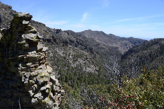
The trail is fine and solid and distinct and nothing at all to worry about as it climbs up to a little spot marked "Red Rocks" which is, indeed, an outcrop of red rocks. They are nice, but my first instinct is to scramble up onto them and get a better view out at all the other red rocks around. There is a little bit of that view I was hoping for.


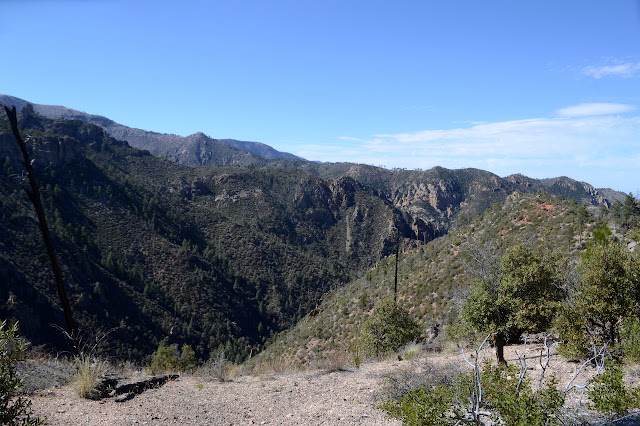
And then the trail drops down into a bland little canyon with a little excitement of rocks at its mouth (see above) but not much else to it. Not quite what I had hoped, but there is still more to climb and it is still part of the overall canyon. The trail continues to be good, although a little soft as it starts a reroute shown on the OpenStreetMap but not the Forest Service quad. The old trail used to go near a spot marked "Log Spring" and I would have liked to have a chance to get more water for the long dry stretch ahead, but not enough to backtrack the old trail when I notice it rejoining. Gradually, ever so gradually, the climb does bring me a view of the lower canyon although at quite some distance.


Just before Horseshoe Saddle, the good trail is suddenly not good at all. A massive boulder sits on the trail and a gully cuts through it along the other side. Someone has placed a stout, but thin, log across the gully and a few others have chosen to just climb down and back up. It looks like a slightly difficult climb. I go whole hog with foolishness and make my way across the stick, it really is just a stick, leaning with both hands against the boulder for balance. It holds for me, at least, so I can continue to the top. This means a couple more gully traverses, but nothing too difficult so long as I make sure that every step will hold before taking the next.

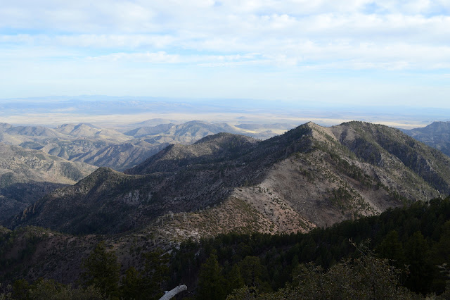
And then I am at the saddle. There should be a trail junction here, but the evidence of it is scattered and burned. I try to take in the little bit of new view before looking around. I have seen a bit of a trail wrapping around the side of the peak, so am not worried about finding the trail. Once I get to looking, there is a cairn to lead me over to a sign that is crumbling, but not burned, in a completely different direction. The maps both say that trail I was seeing is something random and I want to wrap around the other side of the mountain. Also, this is now marked with an even thinner dashed line than the other. I follow the lines on the maps and find myself embarking on a whole new level of bad trail. It is not very long before I am thinking "this is not trail" and stop to look around. I can see a bit of it climbing the other side of a small wash, but it vanishes on the hill before the wash. Following the line it should follow back towards me, I did miss the trail as it stepped a little higher than I did. Back up and try again. There is a little more trail in the missing spot when I actually get to it, but not much. Around the corner, I must thrash through a bit of vegetation that reaches across the trail from both sides. Where it crosses little shoulders, it seems to split into a shortcut version and an out-on-the-shoulder version. More vegetation seems to have trail climbing up over it, but I hesitate. The most likely thing for the trail to do is go through. If I ignore all the branches, that is a sort of curved line. So I push through to trail bed on the far side. And then there are gullies, short and sweet across and long and steep as they go down the mountain. There was trail here once and there is generally a flat step across it, of sorts, now a bunch of feet lower than the trail. I pause and calculate and carefully cross. These challenges keep repeating themselves. Usually it is brush. Long brush sections, short brush sections. Far too many times it is gully. Somehow there is still a noticeable trail bed between most of it, but I find it very reassuring to pull out my fancy new pocket computer and see my GPS dot sitting right by the line on one or the other of the maps on it. Really reassuring. But at least the new view gets better along the way.

Bushes after bushes to push through. And there is this tiny but numerous thorned ceanothus as part of them. At least thorns are usually on one side. I tend not to be all that creative about what songs are running through my head and have never been inspired to a filk, but today is a brand new day and some dreadful Beatles song that was a hit anyway now has the words, "You're going to lose that trail. Yes, yes, you're going to lose that trail. You're going to loo-oo-oo-oo-ose that trail." The one thing that was most clear of the remains of the sign at the saddle was that Sentinel Peak is 4.5 miles off. I have hope that only 3 of those miles is bad. Assuming I can get through at all. The cairn that lead me to the sign post was the last I saw. I did see a single, old, broken branch. The gullies show no sign of humans crossing. The clues seem to say no one is coming this way. Even deer aren't all that interested in it. I find myself looking upon each clear 20 feet with maniacal glee for it is 20 feet I don't have to work at. There are a few sections that show the solid footpath built by the CCC and even with brush these sections make me happy.


The trail climbs up on top of the ridge for a bit and as it is a flat thing on a bit of flat, it is hard to find. I make a guess and as it curves to the north slope, adjust myself to actually be on the now visible trail. A fallen green tree makes one last obstacle a few feet before a trail sign. Thank you, Los Padres National Forest, for all your training. Not just the route finding, but the lessons on pushing through bushes, ignoring thorns, and skipping across wash outs. The last 3 miles over 4 hours took a lot out of me and I still would like a little more water for the long section of dry ahead, and maybe some for camping, so the arrow for Burnt Stump Spring in a quarter mile is tempting. It should be in that third crease along. I could almost believe there is water there. Not flowing, but a general sense of greater green all over. The idea of doing anything extra and then having the extra weight loses. Anyway, I can't stand the words "burnt" and "learnt". I keep on climbing. Now the trail is more distinct, though I suspect that is more to do with the changes in terrain and vegetation than greater visitation. There are more trees down, a few of them still topped with bright green. Ultimately, you can't trust any trees in a burn area. The live ones are weakened too, both directly from the fire and indirectly by not having as much protection from the wind via their neighbors. Now free of the pressures of route finding but still feeling the sentiment, my mind decides my filk could use a verse. "If you don't get those loppers out tonight, you're going to lose that trail. Wilderness will take it out tonight and erase every line."


Toward the top, I have to wind my way through aspens regrowing from their (or perhaps its) vast root system below. A sign alerts me to the small spur to get to the top of Sentinel Peak, so I make the turn and add small fallen aspens to the mix while the new growth intensifies. There is not much left of the lookout that once sat at the top except some trash and a foundation. The views at the top are greatly obscured by the short trees, but not nearly so badly as they will be when spring really kicks off at this elevation.

So I climb back around all the little aspens and back to the main trail and follow it down to the saddle between Sentinel and Finnicum. There is no trail up Finnicum. I was going to go on a spur the short way, but now it feels faster to just climb right over, so that is what I do. The evening is getting cold, especially with the wind coming up. It blows quite hard across Finnicum Peak, so I pull on my windbreaker first. I sign and eat and move on fairly quickly. It is getting late already and I suspect I really need to be another 3 miles down the trail before I stop.


There is a little more trail up the peak as I come down it toward the junction with South Fork Trail. The trail I am on has become the Crest Trail at some point. The junction contains the very first footprint I have seen in a long time. The Crest Trail is like a double wide deer path as it curves its way around the fat peaks. It does not do any particular climbing or dropping, though I suspect that overall it is climbing. I still expect 3 miles from the South Fork Trail junction to Juniper Spring, may it have water and a place to camp. The wind is fierce, I could use a really good place to camp. Just over one saddle, there is one of those snow patches. That's water. At this time of year, it probably takes a certain amount of mining to get it and that pine needle tea from gathering snow before is still too memorable. Actually, it would probably be a "delightful" bug tea from these patches, with some pine thrown in. There is a wide flat spot covered in rounded rocks in a hand grasping size and the floating top of three green trees that have recently smashed to the ground could maybe provide shelter from this wind. Wait, did I really just think that? I walk away thinking about how much I don't want to mine that water, then walk back a quarter of a mile because it is getting so near dark. No, I am wasting time I don't have and this is not the place. I get moving once again.

There are more little snow patches, so I have plenty of chances at that. As I keep trying to move to keep warm and "get there" wherever there is, I find myself walking by moonlight. It is a little past half, so high in the sky and bright enough where the forest has been burned away. The dark path is easy to follow through the light dead grass. I can even spot the paths around the fallen trees, though mostly I go over. There goes Price Canyon Trail, with some nice signs. I am seeing no more promising camp site than what I left. There is shelter where there are trees, but the wind sets up a howl through their tops. Where there are none, I have to take on the wind myself. At least those sheltering trees were already down. The trail gets obscure short of Juniper Spring, but the maps have a suggestion that works and there it is. Easy to find in a concrete trough that is empty and broken. The concrete spring box is broken into and in the bottom is a little pool. The cut Platypus bag that is my water scoop was nowhere to be found when I was packing this morning, but someone has helpfully left a rusted tuna can to scoop the little bit of water. I pull on coat and fingerless mits and get out my light and start scooping. It spills all over, back into the box, as I try to pour it in the bag and the next scoop has a little more dirt. I scoop anyway until there is a minimum for camping.
And where is camp? The saddle offers nothing. Having noted that there is "Cliff Camp" on down Showshed Trail, which has its junction at the spring, I think that sounds good. It even has "Deer Spring" along the way so I might be able to get some better water. The trouble is, so far, I have only located the bit of trail I came in on. I walk off along what looks like trail and the little "phone" helpfully suggest that it is anything but and entirely the wrong way. I walk back and try again and climb a little to find a sign and past the sign, another sign that it replaced (with mystery destination cut out), and past that trail. Aspen again make the going annoying, but after 100 yards there is a space among them almost big enough for my tent. It is lumpy with what looks like an impact crater without a rock in the middle, but lumpy is what puffy mats are for. The rocks form a concave cliff here and leaves the raging wind as no more than some stray breezes even when I hear the trees howl. It is a possibility. The undercut fills me with a psychological crushing feeling that I can't deal with. Trees aren't the only things that fall. The sign said 1 mile to Deer Spring, so I get going.
Snowshed Trail is also no more than a double wide deer track once it gets out of the aspen. There are some spots it get thinner, but I can see it up ahead. I lose it in the saddle, but it is clear enough further on. In fact, it was quite wide once. Near the spring, I can find nothing. No trail, no trough, no trickle of water. Even tiny Juniper has some water trickling around it. But I have water I can use, so I go on. "Cliff Camp" is a thin shoulder out in the wind, but it has a little more, flatter, space for camping. It barely looks like anyone ever has. I want better protection from the wind than low bushes can give and don't care so much about the space or smoothness. There is a trickle of water across the trail shortly before it, but it would be very hard to gather. I have just walked down 1.5 miles in the dark and have in no way bettered my situation. I turn and walk right back up.
The wind is ferocious on the way, and worse for being inconsistent. It pushes me from behind from the left for a bit, then lets up. I hear it coming on again and brace for it, but it knocks me just as hard from my right instead. I somehow manage to only stumble. The saddle is the top of the climb and as I come to it again, I recognize my spot. Small and lumpy, but that is what these inflatable mats are for. It is still beautifully sheltered from the wind. Exactly 10 PM and I can settle down and start cooking. Ooh, and the sediment settled out a bit while I walked those 3 useless miles. Once everything in the pot has boiled, I can set it aside and put away the rest to put up the tent. There is absolutely no way to have both stove and tent set up in the spot at the same time. It doesn't matter, it works better than battling the wind.
On to the NEXT DAY >>
©2019 Valerie Norton
Written 30 April 2019
Written 30 April 2019
Liked this? Interesting? Click the three bars at the top left for the menu to read more or subscribe!


Comments