Silver Peak
Coronado National Forest
Click for map.
I'm not quite sure Chiricahua is a reasonable distance for a day hike from this area or if I'll have to move around for a different approach, so for now I'll start a little smaller. Silver Peak was the site of a lookout tower and has a trail rising 3000 feet in 4.5 miles going up it. That's a very reasonable day hike and it could put me on a much better overlook for the canyons than the short thing done yesterday. The start is easy to find by the big carved wood sign information showing an area map and Smokey and various other very Forest Service things. Although no road signs show this is a trailhead, smaller signs give quite a bit of information about the two trails that are here.

The nature trail is most obvious, but through the fence is a little track. It is delightful not to have to fiddle with a ranch gate and instead step a bit to one side and then the other around a corner that the typical horse or relative can't do. Less delightful is that there is something, probably horses, getting kept in and there are a number of extra trails. There are signs in some key spots, but it can be difficult to decide on what is actually the route and what belongs only to whoever has left all the road apples. A sign pointing to an viewpoint seems to be following one of the extra trails. Another fence (where I can again just step around the ranch gate) puts a stop to it all leaving just one thin trail presumably climbing to the top.


The trail had been a fairly steady climb at first, but now levels off to move around the side of the mountain, leaving the canyon and giving completely different views out across the desert. On up the mountain, there seem to be just a different set of rock structures to get in the way of climbing it on a trail, but all of them look circumnavigable on dirt. Some of the dirt is less attractive than others, but there are lots of routes up.


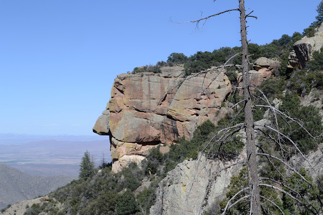
Once a little way around the mountain, the trail starts climbing again. It takes a few short switchbacks and then rounds a little further around, then some more switchbacks. In this way, I traverse past some steep canyons guarded by monoliths of rock.


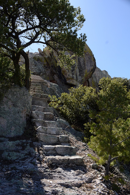
There is one last grand bunch of short switchbacks and I am up on a saddle with an old shed. The top, or getting rather near.


The shed is wrapped in fat wires that hang over its corners and drop to the ground, where a circle of more fat wire is partly embedded in the ground, but mostly staked down. Someone is a little worried about lightning. Well, on the crest of a mountain it is very sensible. The next building along is an outhouse, similarly wrapped and still mostly enclosed and ready to use, provided you don't mind that it hasn't been cleaned in a while and probably could never be properly disinfected as the seat is a bit of painted wood. Then there are some steep stairs up to the top where the fire lookout stood before it burned down. The upper steps have a handrail that looks added on a while back. I'm not sure it meets OSHA standards, but it is enough to reassure someone who doesn't really need it. There are a couple benchmarks, one by the steps and one on the far side.


The view is great at the top, but I head off eventually, back down the narrow steps, past the outhouse, around the shed, and start up the other side on some use trails. There is supposed to be another benchmark on the next peak and it is so very close, I go for it. Along the way, there is a platform of dirt held in with wood from something, then a benchmark newer than the other two. There is another register, too, but this one is getting a lot less signatures. Maybe they left it because there is a sign saying that this is the peak although the horn the lookout is on is higher.


I decide not to continue on to the third peak even though there seems to be a trail or sorts to follow and everything. The afternoon light picks out different features of the rocks than the morning making it sometimes like a different hike down than up even though it is out and back.
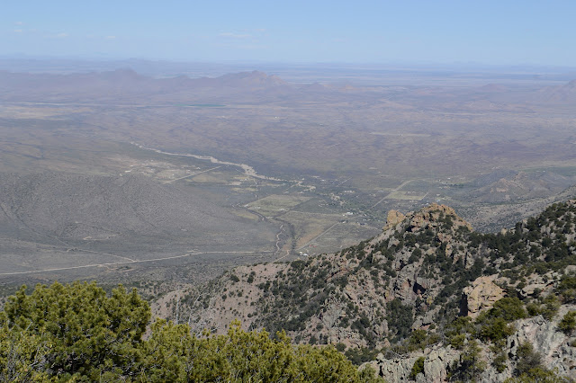


The canyon is also changed as I come back around. The rocks seem to be faded in the late afternoon sun.


©2019 Valerie Norton
Written 25 April 2019
Liked this? Interesting? Click the three bars at the top left for the menu to read more or subscribe!


Comments