Eagle Peak
Gila National Forest
Click for map.
Eagle Peak stands with a little over 2000 feet prominence and is reachable in a long day hike along ridges via Trail 15. The fact that trail is only called by a number is not the greatest anti-enticement to actually walking it. From what I can see from the trailhead, the forest it goes through experienced devastating crown fire that killed and partly consumed every tree near it. Then, someone went through with chain saws and cut down every obviously dead tree that might fall upon the trail or the nearby fence. It is hard to say which they were trying to save. I've never seen that done for a trail, so probably the fence. The trail is cleared, so at least they were thinking about it. Since Eagle Peak is the tallest thing in the local area, I'm just going to try it anyway. Maybe the next mile gets better. Perhaps I'm letting the end justify the means.

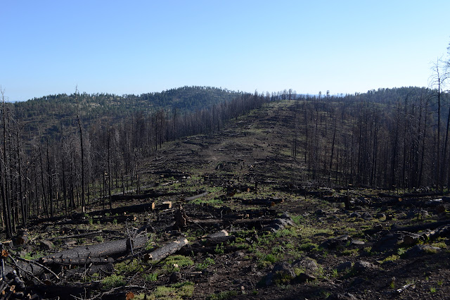
There is a sign to warn me of the dangers of traveling in burned areas although it looks like someone made it a lot safer. The first part of trail has become road, probably from the salvage logging that is going on. There is not supposed to be a road there according to my map and it plunges through the fence where there is no gate only a short way up. Above that, the trail has been driven on, but it has not become a road. Above that, a long dirt depression in a single track is visible. There really is a trail here and it is one that gets used a bit, or did before the fire. Higher still, the long stretch of cut trees in a wide swath is visible.


I find myself at a loss as to which is worse, the burned trees or the swath of cut trees. I tend to think the cut trees, but at least its safe and clears out the views even more than the burn? The effort that must have gone into this is amazing. The trees were tall once and the trail and fence sometimes diverge, so it's a swath hundreds of feet wide of trees cut down. It was not the salvage logging, the trees are all still here, so after they were downed the trail and fence had to be cleared and the fence repaired. Some spots the cleared logs are actually on the trail, but there is a route left and a trail developing. I suspect it is mostly elk causing the new trail to develop, but they're doing a good job so far.
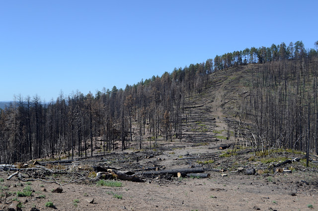
It takes more than a mile, but there is green forest. The whirlwind of chainsaws only took the definitely dead leaving everything else to make a try at living. Some of the singed trees aren't going to make it and a few have fallen over in the wind. Deeper into the green, I start to wonder if the chainsaws quit. Then there is another felled tree or two. At least they didn't have much work.

There is an island of burn within the green and logs lay everywhere with a line cut through them. The level of burn is constantly changing. The level of green of the forest is constantly changing. The green of the ground cover is constantly changing too. Some burned areas are just black while others have growth. Mostly it looks like the fire was too hot and the stored seeds of the opportunistic plants waiting for something just like this died too. A felled tree blocks my path and there are a few indications of incomplete work. End of the work day? So the clearing of the trail is not perfect, but probably better than usual and certainly better than it could have been. Then there is a mystery road complete with gate where is passes the fence. All my maps are incomplete.

The greener forest has animals in it. A single elk sporting some little, fuzzy antlers watches me a bit and trots off. A little later, there is another trotting off first one way and then down the hill. Odd. Ah. Maybe it was the coyote that changed its mind. The coyote seems only a little wary of me, sometimes stopping to watch me before continuing on a show trot down the hills. I look where it came from and there is a cow. All the animals! I suspect there would be more cow pies if the cow were supposed to be here, but the fencing lacks the integrity required to keep the open range from being a little too open.


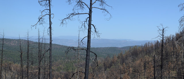
My map seems to indicate I might cross the fence and there is even a gate for it, but there doesn't seem to be trail there now. There are many places where the fence is a little way down the ridge and the trail a little further down it on a slope. Each one seems like it would be more comfortable if it crossed, but it never does. Back in a section of devastating complete burn, I walk a curve along the ridge trying to take in the misty, smoky view to the west, then come to a climb where the trail has been completely forgotten about.
I can see the trail as it swings to my right, out into the standing trunks, then back to the left across the fence. There is even a gate where it crosses. A new trail has been cleared to the low point, but nothing as it climbs the hill. I decide to go for it, popping open the gate even though two posts down I could just walk over it, and walking over the logs that sit on the trail. They are thin logs anyway. There are even a few old cuts visible on well burned logs from before the fire. The map even indicates I should swing around to the left of the hills. Surely this is trail. Except that it fades away. There is an ATV track I follow, which puts me on the mystery road. Or another mystery road. I'm getting too far around, so I go back to where I picked up the ATV track and make a guess. There are some possible indicators of trail, but I am swinging too far off to the side again, so I just cross country back up to the ridge line. Where there is trail with blazes and large mound cairns. On the other side of the fence. So much for my brilliant trail following. It never crosses the fence no matter how tempting.

It doesn't take long to find a place to step over the fence. It hasn't been in very good repair since there was one coming from the right with a trail sized cattle guard on it. So I am back to following the fence. Blazes tell me I am on trail as it turns to drop steeply down for a while. Something below me looks like trail. Down at the saddle, there is more blazed trail. I will have to try it on the way back, see if it climbs the hill more reasonably. There is almost a single switchback for the climb after the saddle, but the actual trail is right next to the fence all the way up. It is getting to be a bit too much a fence maintenance trail. Then I spot an insulator. It looks exactly the same as the ones that once carried a single wire to Reyes Peak and the ones that once carried a single wire to Templeton Camp. I might be on my way to another old lookout. There is another one, this one still stuck in a fallen tree. And then, finally, there is the mountain with a little box on top of it. Definitely a lookout.


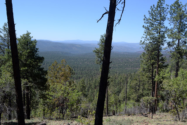
There are some nice switchbacks on the trail after I've finally spotted the peak. I wonder at how I had not been able to see it most of the way. I am also getting the first real views of the day. Unlike John Kerr yesterday, this peak is higher than my start point.

As the trail comes to the base of the mountain, my map shows I have to go all the way to the other side to grab a spur to get to the road that climbs to the top. I don't really feel like doing that. Besides, there seems to be a gate between a pair of trees that are part of a new fence coming from the right and a bit of trail through it. The trail doesn't last very long, so I make my way around toward the north side of the mountain where the road winds, climbing as I go. The last bit to the road takes a bit of work, climbing up a stump, but it works out. The road is surrounded by huge standing dead alder trees. They certainly didn't clear this they way they cleared the trail and fence.

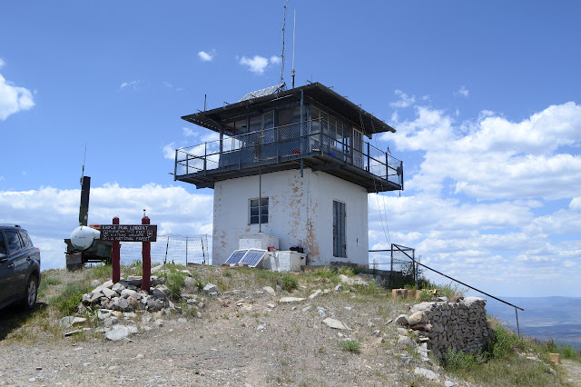
Then it is time to nibble and enjoy the view and end up talking to the lookout, who seems particularly lonely out here, and end up talking a bit too long because I am checking the time on my phone which has just sniffed some Arizona signal with its Arizona time zone. There's a setting for that. Time to take it off automatic. And benchmarks, of course. There is one dated 1966 set in the lookout foundation, so it must have been rebuilt then. There are two stations, one marked Tularosa and one marked Eagle Pk ET.
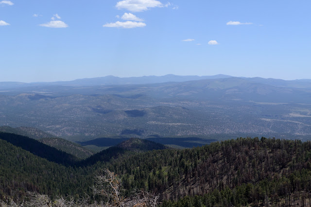
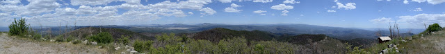

The bump off the side of Eagle Peak is named Buzzard Peak and is listed on Peakbagger, but I'm not really feeling it just now. As I look out, I can only spot my trail in from about where I first spotted the lookout and closer. The lower peaks block quite a lot of the easterly view, so maybe it would be good to go up that one too. It's just over 300 feet to climb it from the saddle. Still, I'm not feeling it. I don't think I saved any effort climbing my own way around the mountain, so I stick to the road and trail. There's a little parking below the open gate next to the trail and another warning about the dangers of traveling burned areas. This is active range and Eagle Peak Spring is set up for the cows to get water just before a gate to leave them behind. One hopes. The fence is in better repair here.

An unofficial looking bit of trail breaks off to the left and I almost miss my trail except that as I start down the other, the blaze to the left almost jumps out at me. Okay, that's the correct trail and this other... has another gate on it. That's right, I was headed for a junction. The sign post is still there, but since it is an unworked piece of wood, the bolt holes are the only indication it was one. There's at least as much of Trail 15 left to go as I have walked already. I'd really rather give it a miss as I'm pretty sure I've gone far enough today and need to get back. It was a little over 10 miles to the lookout. So another danger of going my own way up is almost going extra back. So left, and after a short time I am backtracking.

Finding my way back is easy enough. I do end up missing the first of the switchbacks heading down the hill which forces me to use the cleared area by the fence. It is not cleared in the same way and the logs can be difficult to pass next to it. I am happy to take the rest of the switchbacks. Then there is the hill where I got creative. This side of it is the side that might have a way up, but now I see the gates in the fence. There is a new fence meeting this one from the other side and a gate in all three parts coming to the corner and definitely a bit of trail coming through it. What I hope to be switchbacks probably isn't. I try it anyway. The chainsaws felled a tall tree across everything, but didn't cut it for this trail. There is more maintenance needed further along, but the blazes are easy to see and someone has flagged it recently in pink. I follow it until it starts to head down. A mystery trail not on any of my maps. This is getting to be a theme for this area. I head back up for the direct climb along the set of Trail 15 blazes.

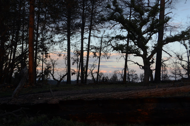
I follow blazes and huge cairns along the trail I missed before. It really goes right over the top of the hill near the fence. At the top, I still can't find where they cut for the trail. It looks like it might get into the trees to my left, but that will be a lot of work to follow because of all the trees felled across it. I follow near the fence instead. This is also a challenge because a fence just doesn't need as much clearing as a trail and sometimes there is only enough space to squeeze by scraping the barbs. Meanwhile, the evening sunlight plays on the land in a half a dozen different ways to give an interesting show.

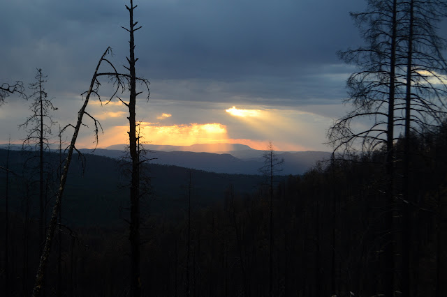
The trail is somewhat hard to find in some spots, but there really are a lot of clues and the fence is always a second chance for something to follow going the same way. I pause looking for the trail to take in the painting of the clouds by sunset, then turn back to looking for the trail. Big. Powerful. Cat. That is NOT my cat. I watch the long, round tail as the mountain lion is making a soundless and easy bound up the hill. The really big mountain lion. It is so close to the top that I only see it a second before it is behind the hill which I am pretty sure is where the trail goes. Fear wells up. Mountain lions hardly every attack people, but it doesn't help. The fear fills me. It's just the second time I've seen the lion, not the second time a lion saw me. Still doesn't help. Maybe it's all the cats through the years including Timmy. I know the whimsical nature and that when the whims hit, so do the paws. It should make it better since I have learned a little how not to trigger those whims. Don't look like food. Don't act like a toy. There is the trail, going around to the right, not over the top where the cat just bounded. So absolutely silent. I walk off a little faster than I was walking before.
Twenty minutes later, I can hear elk shouting the way they were on the hill when they ran too haphazardly off from me yesterday morning on the way to John Kerr. There are only a couple shouts this time. They come from the direction the cat was headed. An elk is a bit big for a cat, but there are plenty of little ones about right now. Or maybe they are shouting for some other reason. I keep walking. I keep the brisk pace for most of the 5 miles remaining. Nothing happens, of course, except for a little spitting rain from those clouds that gathered thicker and thicker in the afternoon and evening. Weather is usually the real danger.
©2019 Valerie Norton
Written 6 Jul 2019
Liked this? Interesting? Click the three bars at the top left for the menu to read more or subscribe!


Comments