El Caso Lookout
Apache National Forest
Click for map.
It's probably about time I made it out of Gila National Forest, but I didn't get all that far. I decided to hike up to yet another lookout from Quemado Lake and whatever else might catch my fancy. Hey, lookouts should have grand views. It's nice to be away from burn warnings, although I have spotted a few around looking exactly the same as the Gila ones, right down to the "Gila National Forest" at the bottom. I might be in Apache, but only the oldest signs say so. The area is administered by Gila. And it's smoky. It wasn't smoky yesterday when I sat and wrote, but now my view is grey. I sure hope it clears out by the time I get to the top. The trail starts at the west end of the first unit of El Caso Campground. (This campground is free. The two closer to the lake are pay, but come with much better views.) It is signed Largo Trail #14 and starts off along a pair of ruts that are the driveway for an inholding further up Largo Creek. At some point, someone put up information signs, one so basic it basically says, "Hey, there's animals out there! Wouldn't it be fun to spot one?" It shows some charismatic mega fauna. A second admits you probably won't see animals, but you certainly will see their tracks pictures some more common tracks. It all sits in a wide canyon with a shallow creek bed contributing absolutely nothing to the very low lake downstream.

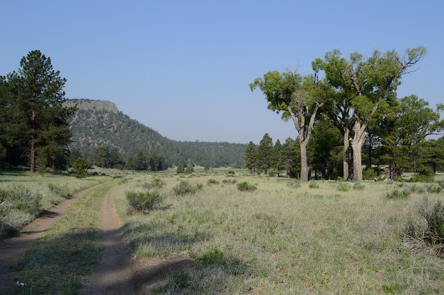
Posts start marking the trail along the side of the road as it crosses the creek bed and turns up along Largo Creek, then start marching out across the flats away from the road. It looks like there was once a bridge to cross it, but now it is long gone, as are a pair of signs. "Bridge out" is my only guess. The creek is a huge pool between them, so I round it at a distance to try to avoid marshiness around it. It almost works, but one foot comes up a bit muddy. The trail is easy the rest of the way to a junction with the Lakeshore Trail.

The junction is well signed but with extremely deflated mileages. It says 2 miles to the lookout but I will be surprised if it is less than 3. Through a real gate for some range land and then onward and upward. The posts still mark the trail that appears to be an old road as it crosses the grasses, then as it resolves into definite old road as it climbs higher.


As the old road bed comes up to a saddle, I have the feeling of being at a major intersection, at least for wilderness. Thick game trail comes down one side and goes up the other. My trail takes a brief rest in climbing before suddenly leaving the old road and starting the real climb. I can't even see the trail as it leaves the road at first, but there are rotting logs across the road and a big cairn beside it to alert me to the change and cairn and a blaze further along, so I can fake it until things settle down. Mostly they do as it takes to following a dry stream nearly in the bed. Unfortunately, it is competing with cow paths.

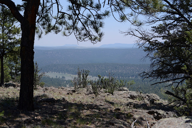
My thoughts as I climb one section is that it'll be nice at the top of the little rise, but something about it seems uncharacteristic of the travel of humans. A desperate look around shows a ribbon slightly askew from the path I took. It takes two more minutes to finally see the trail it is indicating barely out of the bottom of the creek following a different branch than I am on this cow path. It finally turns away from the creek bed to climb. I still feel like I am on some hastily constructed reroute except that there are grown over blazes to indicate route and, secondarily, the age. How long does it take a tree to do that? I just follow it and lament that as I gain a grand view, it is all grey with smoke.

After loads of short switchbacks and a few trees to jump over, there's the top. It comes with a sign that says "vista" and points off to the right. I'm sure there is one, but not quite at this moment. The smoke does not seem to be blowing away. Besides, as I glance in that direction, I can't see where it's trying to direct me. There seems to be no trail or obvious break. There's still some up to go, so I enjoy the relative flat before starting to climb, once again on an old bit of road. There is a reroute where the road is steep and badly eroded, but mostly it sticks to and climbs before getting to the top of the mesa. Then it is flat and down and a little up to the lookout.

The lookout is tall to compensate for being built on a mesa and very obviously abandoned. Steps go up three sides to reach the top and the bottom two flights have been cut out to prevent folks from going up. A challenge! It takes a bit to suppress the urge to step up to this obvious dare. The wooden floor at the top looks intact, but doesn't have the nice metal grate under it to back it up that some lookouts have. The pit toilet stands off to one side cut simply from wood. It has a wooden cover for a wooden hole and no seat. I'm not sure I've ever seen one of that simple design without a half moon cutout in the door. The cabin burned at some point leaving only the steps and the metal that was inside. The road up seems to have seen little use recently. A picnic table was added at some point. Everything is connected by paths carefully lined with large rocks. Someone had a lot of time. My trail has a nice, big sign to mark it. There was another for Leslie Spring, which I was thinking I might go on, a short way back. It should loop around and come up a short way down the road. I'm not thinking I'll do it now. There are two posts from another trail sign that has been removed. I wasn't expecting another, but the rock lining make it hard to miss. I follow it a little way past a tiny coral to the edge of the mesa where it starts to drop toward Sawmill Canyon. Not a way I want to go. Back at the top beside the lookout still daring me, I can find no sign of the benchmark that should be here. There are some possible openings for cisterns all welded shut. It feels like vandalism in the name of safety.


Another thing making me want to go up that lookout is that there just isn't any view at all down on the ground. I think I know why it was abandoned. The smoke still sits in the air, so I would still be denied view at the top. If there is one. Nothing is left for it but to tag the high spot (which takes some guessing after a dip and climb away from the lookout), see if I can't discover the tiny little tank on the map on the second pass (of course, that's what the road I was following at the top was going to, a dry tank), and I think I'll just see this vista after all. Smoke and all. It is still early in the day although it was more than 3 miles to the top from the sign that said 2. It takes me a long time to finally see the trail at a distance, angling back toward the east edge of the mesa. Although there is almost nothing to it at the junction, it is easy to follow after that and looks to have been worked recently. It also gets to a few vistas and just keeps right on going.


The trail is far longer than your typical excursion to a vista as it ignores all the vistas along the way. As it wraps around the edge of the mesa, it also drops and I am beginning to dread that I will have to climb back up it. In for a penny, in for a pound, I guess. I am going to see where this thing goes. A cairn marks a bit of trail out to another vista. A few old cuts and moved rocks show it, but it doesn't get much foot traffic. It leads to some obscured views where some younger oaks were once cut short but have grown back. But this still isn't the end, there is trail continuing downward. I have a sudden sinking suspicion it is going out onto the point that sticks out far below me although there would be no view from the top of that either.
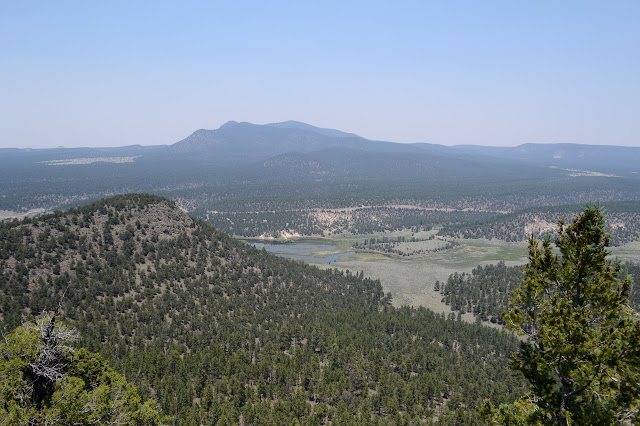

I start down again, but I'm starting to think I might not have to go up. I am getting rather close to a trail marked on the map that just suddenly stops right at the edge of one. Even if it doesn't actually come up further and connect, I bet I could make it. The trail makes little switchbacks down and is getting hard to follow as I keep having to rely on blazes to find it again. Lost again, just as I'm about to backtrack to try again, there is suddenly the best traveled trail of the day right below me. It goes down to the left and up to the right, but it is clearly not about to make the turn to connect with the last blaze I saw. Now I am absolutely certain I will not have to turn back, but first I'll just follow this trail out to wherever it is going, which is almost certainly that spit of land. It is, but not at the top. It comes out a little below the top where the long ridge is bare. Combined with further lessening smoke, it is quite a grand view.


After a while of enjoying that the smoke has finally cleared out a bit, I do have to head on down, but now without any worry about losing the trail. Well, actually, I think I'll grab the point like it was a peak first. It's right there. Lacks views. Easy to get to. Smells like an elk congregation with shi... scat everywhere.

Now down. All is explained a little further down the trail than where I hit it. Instead of simply "vista", it says "Vista Trail". All the vistas are the vista you are looking for, after all. A trail of vistas, not a trail to a vista. I guess. Okay, I might give this one the same interpretation as the one above if I hadn't just walked the whole thing. Down is tree covered, quick and easy. It comes to another unexpected junction, this one with Sawmill Trail #13, so maybe there is a way out if one tries the mystery trail at the top. It is another dim and hard to follow trail. The one I am on continues to be well established and even has benches placed at view spots although the cows can even challenge this one once in a while.

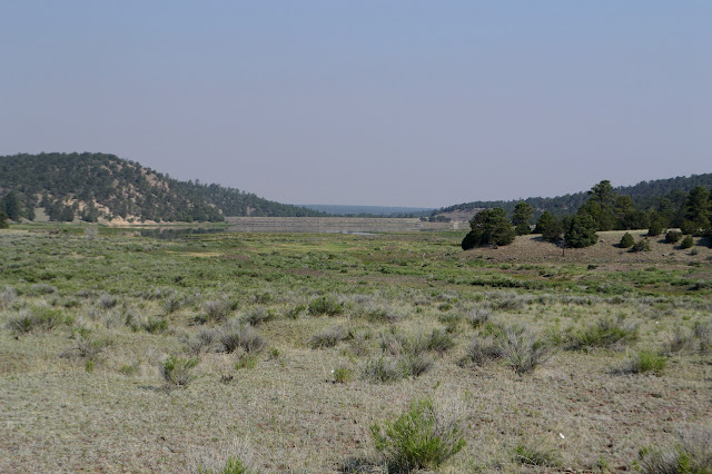
The gate on this trail is open. I guess the cows aren't out yet. There is a flower filled meadow on the way to the Lakeshore Trail at the bottom, where lots of signs point the way. I think I'll continue around the lake to the dam.

The trail sometimes follows so close to the lake shore that I'm sure it would be underwater if the lake were up to its expected height. There was practically no one at the lake when I was looking down on it, but it is still surprising to find bear prints on top of all the other footprints. People are coming out now that the smoke has thinned a lot.


At the dam side trailhead, there is an information sign with information. It states that the footbridge on Trail #14 was removed for "public health and safety" and that hikers should turn back when "they reach the closed area". Oops. It doesn't say why I should turn back. Also, what closed area? A missing bridge does not constitute a closed area. To make them happy, I'll take the mildly shorter route back by the road.

The road is hard and dusty, but I don't have to experience the washboarding and it is good for finding out that Cove Day Use Area has drinking water for all comers. It's always nice to find available drinking water. I'm glad I explored the "vista". It's been a while since I did a loop. Loops are always desirable.
©2019 Valerie Norton
Written 12 Jul 2019
Liked this? Interesting? Click the three bars at the top left for the menu to read more or subscribe!


Comments