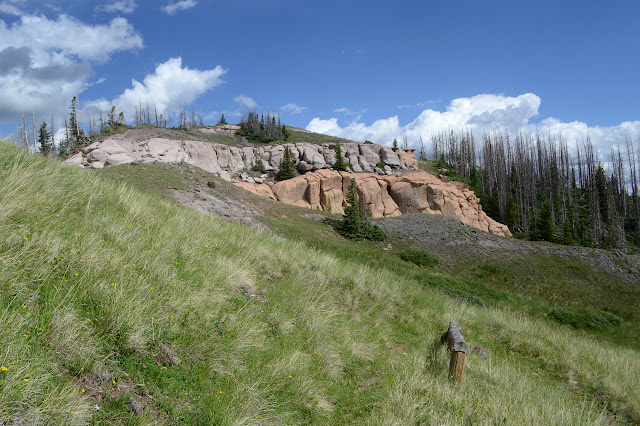
Flat Mountain at the edge of the South San Juan Wilderness
Rio Grande National Forest
Click for map.
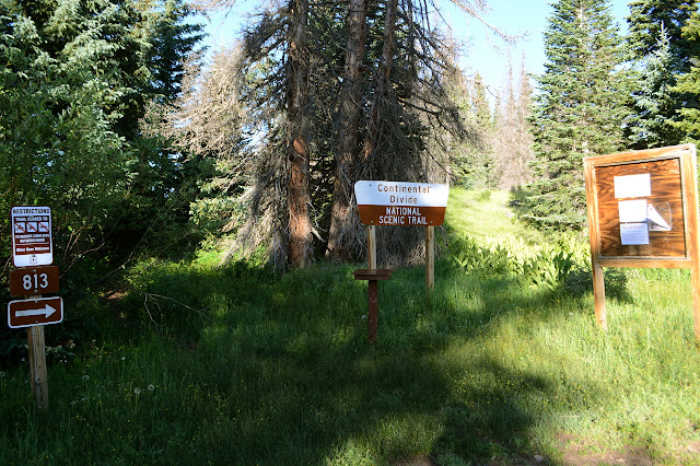
Finding myself once again at a crossing of the Continental Divide Trail (but not as it edges along the Great Divide), I am drawn once again to finding some destination along it to hike to. The benchmark marked FLAT which seems to designate one minor corner of the South San Juan Wilderness looks like a good one, if a little far. I estimate it at 11.5 miles. (Actual: 11.3 miles.) Doable. Especially as the gain really isn't all that much for the length. The trailhead along the old highway behind the train station sits just about exactly at 10k feet and the peak at nearly 12.2k feet. Just 2200 feet gain over 11 miles is what I am willing to erroneously call flat, but then FLAT is the goal. There is a bathroom out of sight of anyone following the trail and a couple possible dispersed camping sites somewhat near the trailhead, but not actually any parking except where it crosses the current highway. For good measure, they don't sign that, just the turns to come in along the old road, so expect a little run around if driving up to do the hike.
From the register, it looks like most people just get as far as Wolf Creek, about three miles in. The through hikers came a month ago with one straggler a couple weeks ago. The trail slips up through the grasses, edges a little near the railroad tracks, then turns into the trees and pops out among meadows edged with more trees and ever increasing views.


There is a kind of explosion in the grass about 6 feet to my left. Startled but attempting calm, I look toward the retreating commotion to find a large faun with a spotted back lunging through the grass. Elk? I know deer simply hide. I though they were supposed to be very still no matter what. I certainly would not have noticed without the sudden movement. The meadow has fences and gates for open range, but they aren't up yet. Presumably that means no cows yet either. As the trail meanders further, it dips to cross first a small stream, then a pair of creeks the second being Wolf Creek because Colorado never tires of teasing me about starting off a hike with 2-2.5 liters of water. It does pause to almost view two waterfalls along the way.


Then it's up again. The trail has had a slight reroute to bring it into a more reasonable slope for the short climb out of the creek valley, then it is back to meadows and views. It is mostly down over the area climbed by the highway.

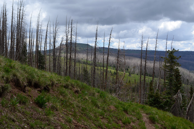
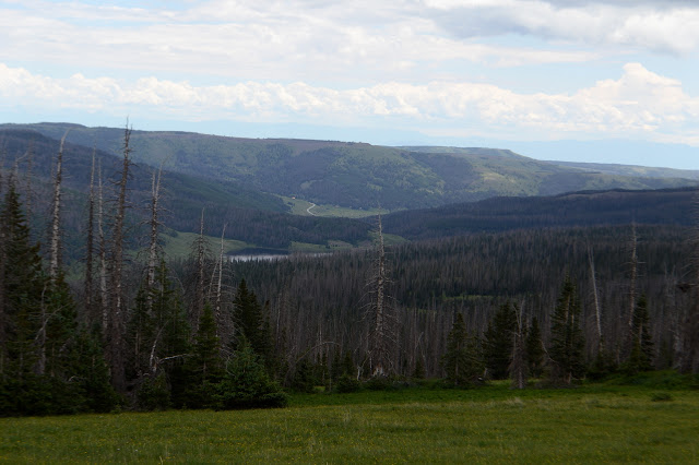
The trail turns away from the valley into forest with plenty of beetle killed trees. Someone has knocked over and stepped on a sign proclaiming dangerous trail conditions ahead. I count myself lucky that there is not a lot of air movement today. It doesn't make it safe, but it does remove one impetus for the trees to come down. The trail flirts with the edge of the county, which is also the edge of the forest. The ranch on the other side of the fence warns against trespassing from time to time. On the other side, marked inholding turns out to be a number of well spaced homes.


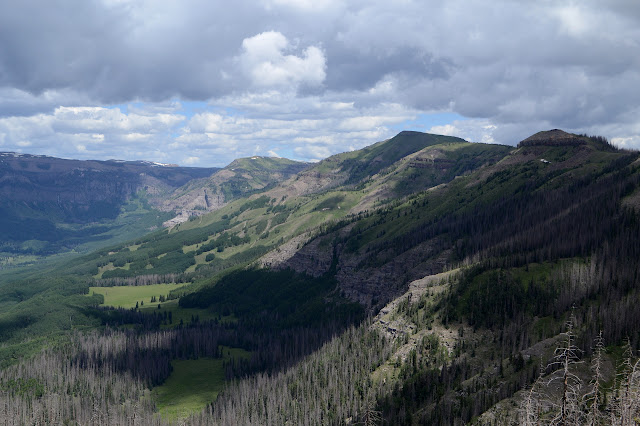
The northern end of the ranch is where three counties come together and my map shows three markers along the edge. One is at the corner, one to the west, and one to the north. It's not too many extra steps to find them, so I go to check out that corner, then march my way along the fence to the one to the west. Give my best smile and wave to the camera pointed north approximately where my map shows a trail boldly crossing into the ranch. Got to look my best if it's real and if it takes a photo at the right instant. Then the last short way to the westerly marker, stuck on a cliff edge of the Rio Chama valley. Wow. That's some valley.


I'll stop for the third monument on the way back. I missed it as I went cross country to the second. There seems to be a handy sign to mark the trail for easy finding again. Maybe this once was a junction, but it has no destination that isn't north. Its weathered surface is getting hard to read. Continental Divide Trail No. 813, Flat Mountain 4, Dipping Lakes 8. Maybe as the crow flies. I walk off, then realize I can actually check that. It is 4.03 miles to the benchmark. There aren't a lot of people looking for the straight line distance on a hiking trail sign. Then it is onward and slightly upward with that magnificent valley to the side.


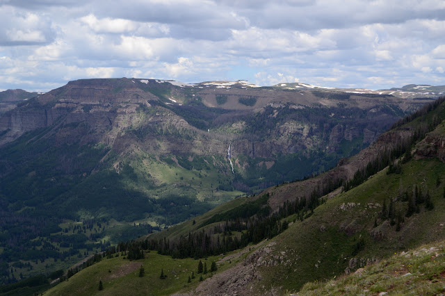
I stop for a while just to look about. Okay, maybe also to eat. Even a slow uphill needs some energy. The long, flat peak that is my goal is easy to pick out on the edge of the clearly glacial canyon. Someone was telling me recently that the peaks here got to stick up out of the snow. I wonder for a moment how that must have looked before remembering the Harding Icefield. So long ago, but it should have been about like that. Maybe even with the goats. Maybe not. A tall waterfall catches my attention across the gulf. It is determined to be in the shadow of clouds, but I watch it anyway. How much water is coming over the cliffs to be able to see it across this gulf?
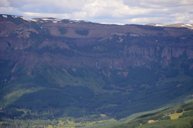

The waterfall doesn't come out of shadow as I watch. The clouds have been getting worse and it is not lost on me that I seem to be aiming to be on a wide, flat mountain at the prime time for lightning. I should probably make some changes for the season. Either earlier starts or shorter hikes. For today, it is just wait and see.

The trail traveling gently upward has been variously dirt or small rock slabs as it passes hillside or rock slide. It takes a turn for a valley topped with colorful ash and the dirt must get deeper because there are deep marmot holes all over. One is right in the middle of the trail and seems prepared to swallow up an entire leg of an unwary traveler. They sure hide a viciousness in their cute.

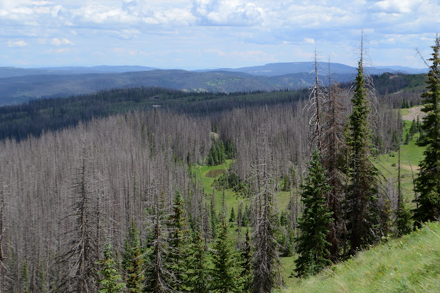
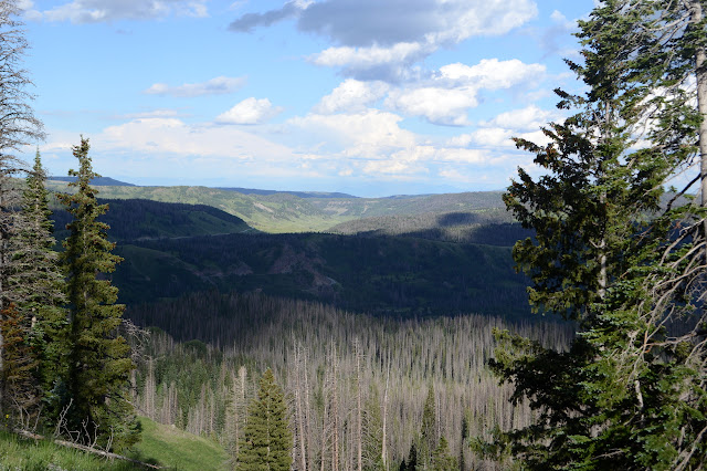
There are some easy switchbacks in the grass, then the trail reaches the top of the ridge line. Now there is view on both sides. There is a grey pal over the area of Rio de los Pinos as it flows down to Trujillo Meadows. The beetle kill on this side is more extensive and makes the whole valley seem like death. I certainly did not notice it yesterday in the bright sunshine and surrounded by the green of the reservoir.
On I go. I'm expecting a couple trails to come up from the east, but only one, a little misplaced, appears. These both would grant someone with 4WD a much easier access to the peak. Well, if the roads are open. I noticed a sign about "responsible logging of dead trees by" so-and-so on the way to the reservoir yesterday. I'm sure that means just the big ones, but someone also pulled together some giant slash piles by the road. I expect those go up when the snows come down. Still brave to light them up.


Another dangerous trail sign is stuck for northbound hikers to see, but I'm not sure what it is trying to call out as the trees are all below. Someone has scratched in "some downed trees, nothing big" showing a complete lack of understanding that it is the standing ones that have the most potential for harm beyond a few scratches. There is a trail post with extra pieces of wood stuck in the rocks with it. Maybe they were once part of a sign and that is the second junction I was expecting to see? No other trail is evident. The important bit for me is that last push upward and some of that is all too evident. An eroded bit makes difficult walking before a switchback leaves it behind.


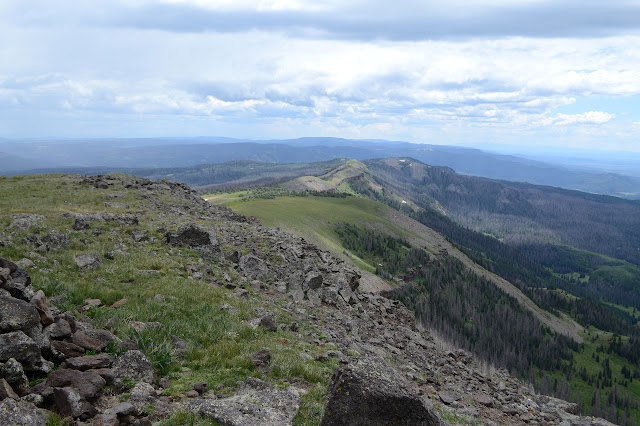
There is no wilderness sign at the top to herald the last possible place to meet a bicycle for a while. There is no benchmark either, no matter how much I search. There is a metal post embedded in a rock near a rock shelter. That was probably it, once. There don't seem to be any references either. There are a whole lot more mountains along the horizon to the north.


As the sun hits it again, I am pondering how to get to that waterfall. It's getting a little warm, I've been happy to have the shade of the clouds most the way, and the valley is much lower, so maybe now is not the time. On the other hand, that is a tiny drainage it comes from, so perhaps now is the only time. I think there are trails. Fairly certain. And if not, surely it would not be so hard anyway.

Nothing determined on the waterfall, I head back. It is a long way back. 11.3 miles, to be exact.


I have figured out where the Dipping Lakes are, so back at the sign I'm ready to see if they are also 8 miles away as the straight line distance. Only 7.3 miles. The trail is not anything like straight to get there. Not quite consistent. Then off to find the last benchmark after staying a little closer to the trail in the last of the falling trees. It isn't easy. The benchmark is there, but no view. I am surprised to find a huge old "private property" sign when I turn around. It is very distinctly nailed to a now fallen Forest Service tree. You desecrate your own trees like that! This marker was set in 1937 and the other two in 1943. The sign isn't that old, the clues were here.
It is an evening of deer as I pass through the broken forest with so many beetle killed trees. I feel done with hiking about 3 miles short of the end. That is the trouble with a 20+ mile day. I must go on, so I do go on, and try to distract myself with the sunset colors as they come in the last mile. Also the same explosion of faun, this time zooming directly down the hill, then stopping to look back at me. You got me twice, little one, but I suppose I got you too.

There is rain in the sunset once again as, however they feel about it, my feet bring me back to the start and the car.
©2019 Valerie Norton
Written 19 Aug 2019
Liked this? Interesting? Click the three bars at the top left for the menu to read more or subscribe!


Comments