Carson Opening
Six Rivers National Forest
Trinity National Forest
(Map link.)
FR-1 is among heavily burned trees as it turns south on South Fork Mountain and it stays that way. It was a long stretch of road before I found anything that resembled a usable parking spot, much less something I might want to park in. I found that at Carson Opening. Apparently I stopped just before the public lands. There is a large swath of inholding generally east of the road until that point. There is a huge open area west of the road, south of a "private lands" sign. I walked along it and up a small spur near a high point to take in the area of Pilot Creek and the surrounding ridges. As long as the wind isn't blowing hard, the spot could make a nice dispersed camping spot and I suspect it has been.


So none of my plans worked out for the day. I had already passed by the starting point for both trails. I really really didn't want to stop the car in the spaces where the trails start.
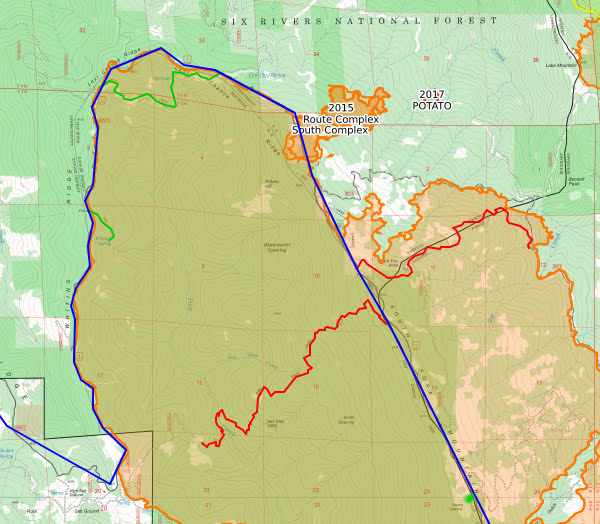
The above map shows the driving in blue and my hiking plans in red. The green dot in the southeast is Carson Opening, where the pictures above were taken. The green line on the west side is Whiting Spring 5E41 on Whiting Ridge, which I did hike. The northern green line is 5E39, which I would call Last Chance Trail, but that name seems to belong to 5E55 which parallels FR-1 as it crosses South Fork Mountain. It is a motorcycle and ATV trail and was marked among the green trees on the west side and may have made a fun little hike among the headwater areas of Pilot Creek.
The first trail for my plans, heading east, turns out to be almost entirely within a vast inholding. I hadn't realized this because the Forest Service layer (FSTopo 2016 (green), specifically) doesn't show inholdings. However, when I loaded it up in Oruxmaps on my downloaded Forest Service quadrangles, I immediately saw all the grey it passes through. This trail goes past Black Fox Rock with a nearby spring in the first mile and that piqued my interest. I did also happen to notice (while trying to find Wallace Camp) that this route is just the old road for the area now served by 3N14, so any right of way is likely to have been transferred. I certainly saw no sign of trail as I passed. I guess that is just not to be.
The second trail for my plans going off to the west is Dan East Trail 5E14. This one is a motorcycle trail. I did not see it marked, but I'm not certain it actually comes all the way up to the road. I was expecting to have to travel a little on Last Chance Trail 5E55 or do a very short cross country. I was particularly impressed with how dangerous the trees of the area looked and had no desire to stop there and leave the car for a few hours. I might try again from the west side.
I decided to stop at Blake Spring Campground and poke around a little there. (It'll be signed, right? Not even remotely.) So much for planning.
*photo album*
©2021 Valerie Norton
Written 11 Jun 2021
Liked this? Interesting? Click the three bars at the top left for the menu to read more or subscribe!


Comments