Pinorealosa Mountain
Rio Grande National Forest
Click for map.
Another day when I am absolutely certain it is just going to rain on me, but I still can't guess at this weather well, so I'm going anyway. Pinorealosa Mountain has a road up it, but after the yurt (which you can rent, at least in winter) it becomes rather rough for a small car. At least according to the map. I decided to take La Manga Stock Driveway up, except it seems to have vanished from reality. Instead I'm starting at the road to La Manga Cow Camp and then I guess just cross country up the mountain to the top. Once at the top, I've got the high point in the middle, a geocache at the far south end where the finders claim there's a fun rock outcrop, then back north for a benchmark and down again. At least starting at the road means there is a (locked) gate instead of barbed wire to pass the fence around the administrative pasture by the cow camp.

The road also gets me across the creek in the middle of the meadow without threatening to wet my feet. The stock driveway probably would have made crossing without muddy everything quite a challenge. There's a number of horses hanging around the cow camp, so I expect it is occupied. Guess I won't poke around and see what all is there. From the distance of the road, I can tell there are two buildings.


There is another gate behind the cow camp, but this one is an unlocked ranch gate. I give it maybe too half-hearted an effort before carefully slipping through instead. It is way too tight for me to open. Shall I go to the stock driveway or just start up? The area has been chewed up by loggers coming after the dead trees and the road is easy to walk, so I stick to the road until the driveway. I still can't see where the driveway should be, but the climb looks less full of stumbling sticks from dead trees broken up by loggers. Whatever. Upward. My feet carefully kept dry are quickly wet by grasses.


I climb along mildly used logger route for a while, but as the trees become mostly live, the rolled over ground vanishes. It is nice to be among mostly green trees although they all seem so small.

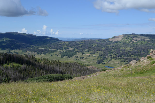
The slope eases off quickly at the top and the trees are rather thin so that there is a view. I seem to have accidentally aimed myself right at the high point.


I head for the high point. There is one more fence, seeming in good repair, to navigate just before the road. It would be easier to squeeze through these if they were just the normal 3 rows of barbs. Why do they have to be so narrow? Still, it just takes a little care. Across the road, the high point seems to be rather tree covered. That must be why the benchmark is on a smaller peak to the north. It is so flat, I'm not sure which way is uphill, so am going more by GPS to find where someone thinks it is. My foot makes a splat and then there is a fragrance. I have just put my shoe perfectly centered in a cow patty twice as wide as my foot is long. Fresh with a thin, dried layer around, but I just broke that layer to bring it out again. Ugh. The cows that left it are hanging out at the presumed "peak", but run off to give me my moment of whatever. It isn't a very good peak.

Hopefully it's a better mountain than peak. There is a clearer route heading southwest back to the road, so I go for that. Carefully. I might find something deeper and worse to step in otherwise. Then it's just south along the road, which is super easy to walk although does have some spots a bit rough for a small car, as promised.


My destination for the geocache is so far south that I'm starting down the side of the mountain before I get there, but it does open up quite a view. The rocks are only a little way down, then back up off road. The road itself continues for a long time downward into the bright green valley below.


There are game trails and maybe even some people trail to get down to the rocks. The fence here is in poor repair. Hopefully that means no cows. It certainly looks like a place to find cows.


The find is quick enough. Half the signatures seem to be accidental finders, which speaks to the popularity of poking around these random rocks. As I turn back, I seem to be marching toward rain. The poncho comes out around the junction as I watch a long line of ATVs head down the rougher road along the fence. It isn't all that needed on the way to the benchmark. Maybe a little more useful than the canoe and row boat strapped to the top of a Jeep that is also making its way the other direction in the rain.


There is a post off the side of the road as I near where the benchmark is marked on the map. The area is more clear than the high point, but disappointingly tree covered all the same. I pop over to find that this is just a reference mark. The station is a little further on. But now I have an arrow to follow, right into a bunch of trees. A little off the direction of the arrow, there are a pair of rock circles, but neither seems to surround a station. Just the other side of the trees is an old stand that should have been over the station once. Wires are tied to trees and rocks and leave me a way to estimate the middle, but nothing is there. I am at a loss as to how some of the wires and sticks might have gotten wound through the nearby trees as they are. Maybe center isn't center? It seems like odd physics has been at work. I circle and circle wider to find another reference. The first was #2, so there has to be another. Once. There doesn't seem to be now. Still, the clues left should be clear to find the station. It can't have been plowed off somewhere if the stand is still here, surely? The search only accomplishes waiting for the sun to come out.


I finally give it up even though it should be so clear and easy. No station to be found, no reference #1. Originally, I figured I would go back to the trail to get down, but since I didn't find a trail, I just start from the benchmark. Once more, carefully through a well maintained fence of barbs and down. The hill side is steeper here, but riddled with animal trails. Most of them maintain elevation, but there are a few climbing or dropping to make my way easier. They seem to focus on getting to a small shoulder, which is a nice stop along the way before hitting slope again.

Again, I am dropping almost directly to where I want to be, by the cow camp, without really trying. Unfortunately, that does mean more area thrashed by logger vehicles and even a few slash piles to navigate. At least today I can manage enough care not to get tripped up by it all constantly while on a downhill slope. All is easy once on the road again, except that one more bit of barbs to navigate.


Then I'm back after 8 miles that seemed quite short. Maybe I should have wandered to the north side and seen if it had something of an interesting view to offer too. They wouldn't put a yurt just any old place, would they? Perhaps the rougher spur to see the east? The drive back to camp is only 5 miles, but it goes from sunny to raining to raining hard to sunny again along it. No wonder I can't tell what the weather will be like around here.
©2019 Valerie Norton
Written 27 Aug 2019
Liked this? Interesting? Click the three bars at the top left for the menu to read more or subscribe!


Comments