New Mexico/Colorado State Line on the CDT
Rio Grande National Forest
Carson National Forest
Click for map.
Okay, I admit it, the only reason I set off on this hike was to cross the state line on foot and maybe find a marker. The map says there's one right on the line very close to the trail crossing. County? State? Forest? No idea. They all have a boundary there. For the rest of my planning, I figure if I go 6 or 7 miles, the hike will be about half in each state. Anyway, more random miles on the Continental Divide Trail. A pair of tents has sprouted on the north side of the highway and the cuben fiber one talks as I go by. No wonder those things are so expensive! They're too late for northbounders and too early for southbounders but perhaps with the heavy snow they are simply determined-to-do-the-high-route-bounders who have reordered their northbound miles. Or section hikers. Or just getting started, but it seems unusual that they would be camping at the start and no car nearby. I completely fail to ask the talking tent, so will never know.

The weather is threatening again. It is always threatening. I am always certain it will rain. If I try to avoid it, I'll never get to go anywhere. It seems like most of the time the promises aren't even fulfilled, or at least not with any vigor. I have my poncho, I can keep... dry enough.


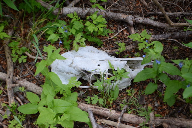
There is actually one other benchmark near the trail, so I spend a little time looking for it. Maybe the sun will come out if I delay a little. I don't have much hope because it is down under trees and among quite a lot of undergrowth which serves to make my trousers quite soggy from the knee down, but it is there. There are at least three bearing trees to help out and a witness post right next to it. It's a good thing because it's a short little thing surrounded by a rock ring and overgrown with flowers.

I check the bearing trees to see what their posters say. The distance is measured in links. There's one every now and then who feels the need to use chains and links. Anyway, onward and for now upward and startle quite a lot of elk innocently grazing on the lush grasses.


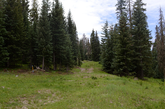
The state line comes around 3 miles along with decorations both official and not. The marker promised by the map is off to the side. It does indeed mark the state line, but with an unexpected twist.


Of course, the beetle kill doesn't stop with the state line. So many dead trees. They don't even seem to lessen around the creek where there is plenty of water, so it doesn't seem to be a matter of too many trees for the land. Anyway, that's supposed to be one of the problems with bark beetles and these are engraver beetles. I'd been assuming they were just different common names, but maybe they're a different scourge too. One section is so bad it shows clear signs that the trail trail is moving around due to the trees coming down. It gets work, but the workers can't keep up.


The trail is running parallel above an old logging road as I'm closing in on my 6 to 7 mile plan. I thought it would put me around a section where the trail follows roads both open and closed. There is a loop of road that should give different views, so I'll make that my turn around. The CDT dumps onto open road next to a "road closed" sign. There is a rather large tree next to it that makes me think it never was a road, but they could just be being thorough with the signs on hand.

The road section is brief before the trail moves onto a closed road. Curiously, this closure sign seems to have better compliance than some others. The grassy flat is nice and easy to follow until it encounters streams. There it is a soggy mess with water primarily following where people walk and it all happens invisibly under thick grass. It is a challenge to get through without sinking into the mud and I fail it a couple times with unpleasant results.


Another open road comes up from below and the trail dumps out on it once again. A little further, the trail continues on between a couple closed roads. This is my turn around spot. I don't quite feel tired enough to be turning around just yet. Maybe Peakbagger has a suggestion for a nice peak in the neighborhood? It has two suggestions, neither of which have been given a name. One is a little further out and doesn't look promising, but the other is back the way I came, has 840 feet prominence, and little vegetation on the top. That has potential. I could just follow a ridge a short way from the road I want to loop back on just before it drops back to the trail junction for the return. So that's a little more plan.
As the road loops around, there are only a few open spots among the trees to try to get a view of the world nearby. I have to marvel at the way the road has been cleared in a very minimal way. A big tree sits most of the way across with a cut at the end leaving just enough room for whatever vehicle was carrying the chainsaw to squeeze by on the verge. Smaller trees have been simply run over, often around the edge of the road where the tree is lower to the ground. A few more average trees have been cleared only halfway, too. The map does indicate unimproved dirt road, but I would expect that when folks get out to do their own improvements, they might clear the road more completely, especially when it wouldn't even mean more work.


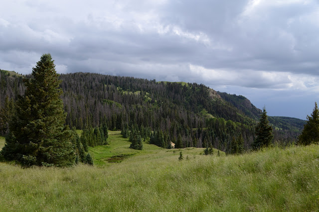
At the ridge line, the forest does not look all that inviting. There are trees down along the side of the road, making the way a little rough. I look a little further and it changes as I notice the elk trails. Elk don't like going over anything too high either. Some of them do stop by a smaller meadow on the way, but after a few choices, there is just a long bit of grass to wander upward in to the rather good view.


It was definitely worth the little jaunt off trail to get the peak, especially with the bright weather moment, but the weather is deteriorating again and it is probably time to be heading back. There is a turn off the main ridge to get to the road and I seem to try to miss it because travel is really rather easy along that spine and thus faster than expected. I still get there, then back down to the trail to follow it back. Now that I'm not looking as hard for where it goes in the section of many fallen trees, I can notice the flourishes one of the trail clearers has added. One tree was apparently cut by Zorro, who left his signature "Z", another is marked for the theater although the crying side looks more like the cartoon shorthand for dead.


The changeable weather changes again and is improving as I approach the state line. There is rain out there somewhere and sometimes a few drops on me, but mostly it just fluctuates and never quite gets to any specific weather type.


Back at the pass, I'm just a bit more satisfied with the hike than I thought I might be. The peak really was a little unexpected jewel and it didn't take much extra work to get it. The benchmark at the state line was also more than expected. It's nice to see something from a different agency, and in fact different branch of government, than usual.
©2019 Valerie Norton
Written 27 Aug 2019
Liked this? Interesting? Click the three bars at the top left for the menu to read more or subscribe!


Comments