Elliot Peak
San Juan National Forest
(map link)
I was collecting things together to backpack a small loop on the Calico National Recreation Trail from the Priest Gulch Trailhead when a pair of backpackers just finished with through hiking the 19 miles popped up. The usual hiker greetings are important, for they give the opportunity to then gain information. In this case, this spring on the map, is it any good? If it is good, there is an excellent opportunity to grab a few peaks. As it turns out, they had searched out that spring and creative water gathering was required because they did not find it. Almost all of the water to be found on the ridge was snow. I am not a fan of this particular water source, personally. Third worst water ever. Anyway, if I'm looking for views and possible peak bagging, I should be at the other end. This loop will be entirely in forest. Yes, even the ridgeline that Calico follows. I could follow them there, if I liked. So I took this advice, although I'm not sure she was really taking my vehicle into account when calling it a good road. I nearly got stuck in soft crud on the first switchback on Dunton Road, a rough and narrow thing as it comes of CO-145. Only a few sections required a careful creep in first gear, though. Then, with explicit descriptions of the last water before the ridge and the single little bit of running water on the ridge, I got to collecting things again. I was slowed somewhat because the mosquitoes in Dunton Meadows were really good at gathering around in excessive numbers, but got going in the late morning.

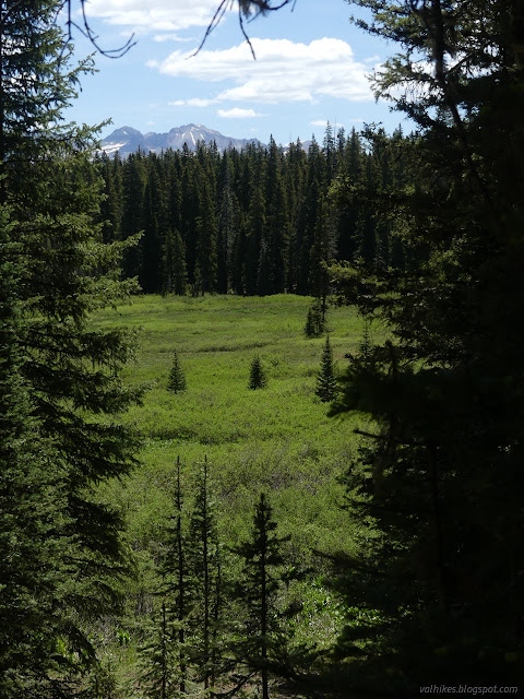
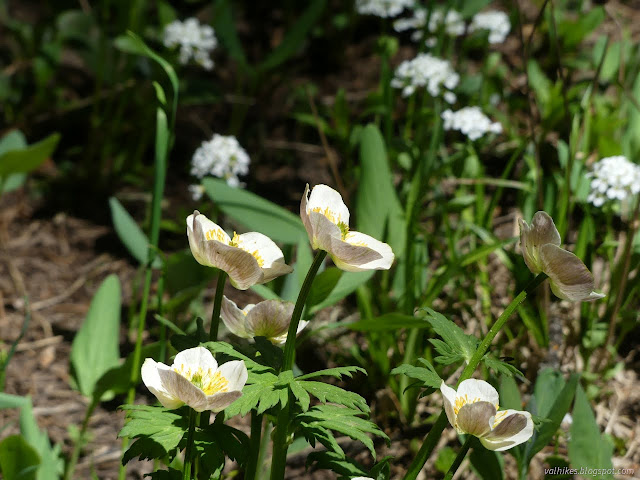
Calico NRT is a motorcycle trail, as are East and West Fall Creek Trails. The Priest Gulch Trail, which would have made my loop, and various trails that drop down to CO-145 are generally not. All the details of trail use are on the sign at the parking lot and on signs at the intersections. It wasn't long before I met mountain bike and dirt bike users. The signs expect horses, but they do like to avoid the wheeled ones. Prints in the dirt indicated hikers are pretty common, too. I hiked up through open meadows full of flowers and, once in a while, a hint of the views to come.


It was about half a mile in when I realized I'd forgotten the trowel and other bathroom type items. But I could kick the ground with my foot to dig a hole. This is really only half true depending on the ground at hand, but my hiking poles could be pressed to be digging sticks. I had tissues stashed away because I got the nastiest bloody nose a few days before starting off from New Mexico again and it keeps coming back. I didn't have to go back for that.


I was about two miles in when I realized I had no fuel to go with my stove. I started back, but then sat down and ate a while. I thought about it. The titanium pot with the tight, but not locking, lid is certainly not my choice for cold soaking, but it could be done once in camp. My food wasn't chosen for an optimal cold soak, but it could be done too. I didn't really need to go back for that. I decided to keep on climbing after all.


I came upon the described last water and settled down to get some. It didn't work well. I should have checked the water filter. It wasn't letting anything more than a few drops through. I waited and ate and found the water level indistinguishable from before. This one had been rather slow in October, but was flowing okay after hanging an hour and was flowing well after a few more uses. I didn't feel like I had that sort of time, so disassembled and tucked everything, including a liter of "dirty" water away in my pack.

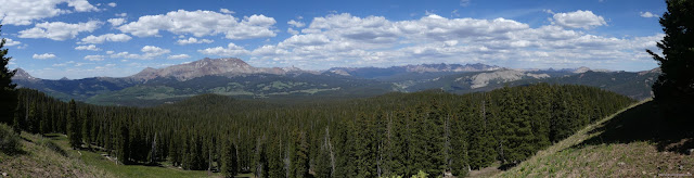
I left the trees and reached the ridge top. It is wide and flat with the trail down the middle, so I wandered off a little to the side to find the more extensive view there. It's good to be above the trees, especially when it's a bit early in the year for afternoon lightning storms.

I stopped by Pappose Peak, which is really no more than a shoulder but it says it has a benchmark, on the way. I searched for the benchmark and found a plethora of different flowers and a metal pipe with paint on it, but no benchmark. It looks like the kind of spot that will swallow up rock and benchmark whole. I tried again to get the water filter to work a little and it refused.


I was getting thirsty, but I packed up and got going again. I met some motorcyclists who had decided to turn around somewhere along here because it got too technical. The trail does get a bit rough. Along the side of Elliot Mountain it gets narrow, jagged, uneven, has random steps of a foot, and a long drop down. I guess I could see turning around.


Halfway along the side of Elliot Mountain, I realized I wasn't wearing my sunglasses. I'd put my new sunglasses on while I was packing as the trailhead is already at high elevation and it's a good idea to wear the things, but they kept hanging from my ears in annoying ways and got set down on top of the car. Which I then reversed into a shady spot when the lot had cleared. Which could well have ended up smashing the things. I might have got to wear them a whole 10 minutes before losing them. This particular missing item made me particularly frustrated as I've been trying to protect my eyes better. I decided it was time to call the trip. On the other hand, there was Elliot beside me. A p2k, no less. Easy to go up from the saddle on the far side, according to my informant met at the other trailhead. I decided I would have to bag it, then go back.

So I went up and I drank the last drops of the water I'd brought and I got thirstier and thirstier.

I got to the top and failed to filter water again and ultimately just poured it through a cloth to make sure there were no muddy bits and drank down half of it. The rest went into the bag for later. I've got to question why I have a little bottle of iodine tablets in the first aid kit if I insist on forgetting about it when needed.


I heard a strange bugling noise down the side of the mountain and poked my head over to see an elk scampering down the side of the mountain. She stopped and looked at me a while.

I wandered along the top of the ridge about halfway before deciding it would be much easier on the trail. Not that getting to the trail was easy, but I chose a section where there wasn't a slide of rocks and managed it. Then I walked right on back to the car having failed to use much of the stuff in my pack.


I got back shortly before dark and performed a long search for my new sunglasses before accidentally finding them on the ground in a completely unexpected place. They weren't crushed. Then I faced that it was getting dark on a Friday night and I now needed to find a campsite in an area likely to be popular for dispersed camping in Colorado where they do a lot of dispersed camping. The spot deep in the trees across from the trailhead was quite taken already, but I managed.
*photo album*
©2022 Valerie Norton
Written 1 Jul 2022
Liked this? Interesting? Click the three bars at the top left for the menu to read more or subscribe!


Comments