Boulder Loop: Doe Lake, Eagle Peak, and Telephone Lake
Shasta-Trinity National Forest
Klamath National Forest
(yellow line, map link)
DAY 1 | DAY 2 | DAY 3 | DAY 4 | DAY 5 | DAY 6
My plan for the day was to continue along the trail to Doe Lake and on to what signs would tell me was Bloody Run. Just short of the run running into the PCT, I would turn to take a trail halfway between it and Eagle Creek which curves around to Big Marshy Lake. That's the nice end point by miles, but I'm very hesitant to camp by things called "Marshy" as they seem to imply "mosquito-y", so push on past that and the marked marsh and up and over to East Boulder Lake. I didn't get quite so early a start as the day before, but it was still before 8AM as I took off.

Unfortunately, I really needed to get more than just the one bag of water the night before and I didn't have any hiking water for the three dry miles of trail coming up. I stopped to get some and ate up the rest of my earlish start.


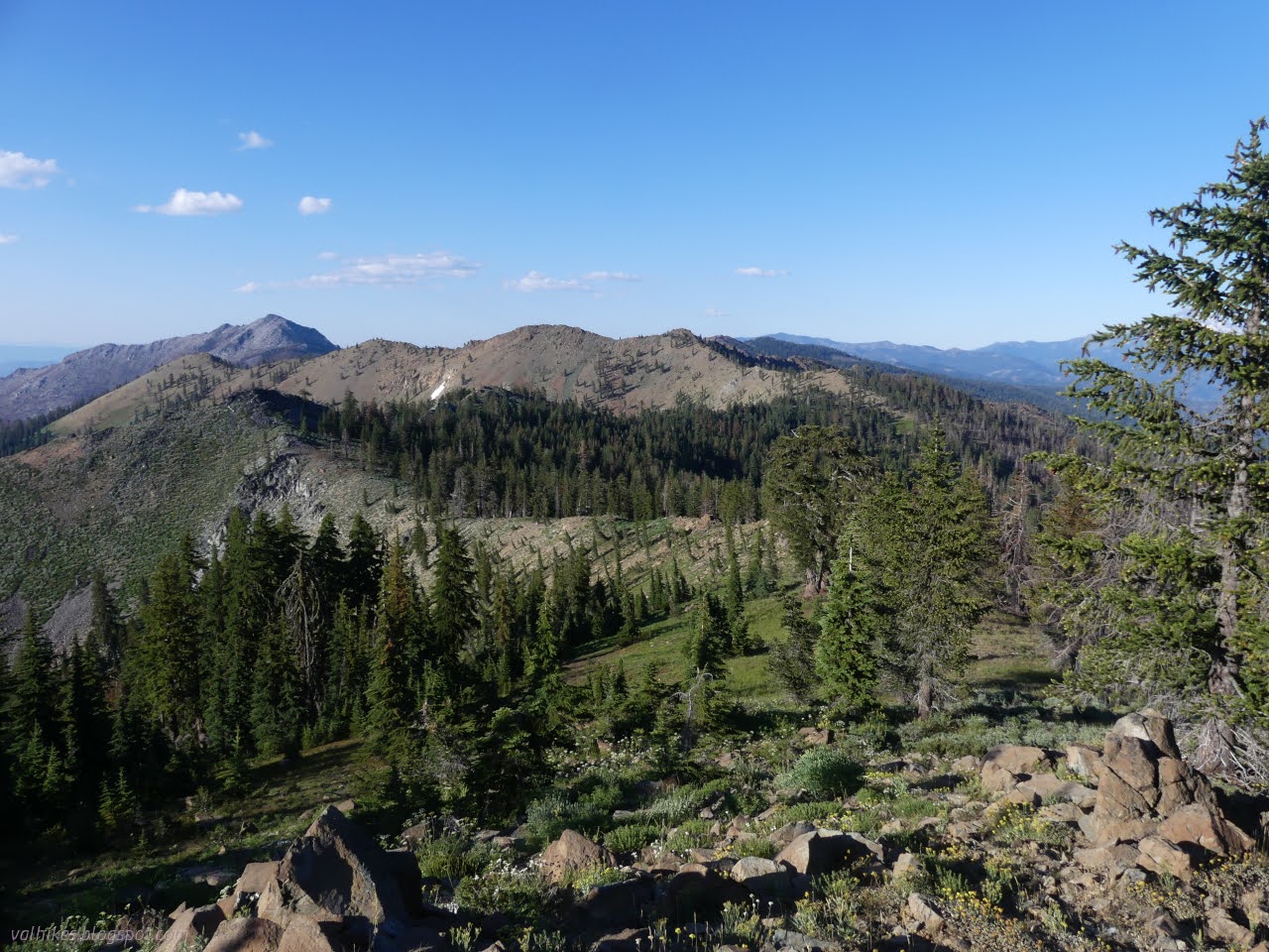
Trail isn't all that clear across the inflows or up the side to the ridge above, but from a tall cairn marking the way down into the next valley it is actually quite good. There's a couple very short spots where trail is hard to see in little meadows and a pair of trees requiring a big walk around, but the route is always obvious.


I followed a lot of deer prints over the edge of the ridge to a grand view at the top.

The trail was even nicer up along the ridge. There was a tempting game trail trying to lead me astray, but otherwise it was just clear trail with a few logs to step over. In fact, there seemed to be a lot fewer logs everywhere than might be expected. There were plenty of charred stumps but little still standing and little on the ground. I finally realized this area was twice burned.


I stopped by the rocks of the last view of the tall, snowy mountains for some snacking.

From there, the trail climbs up and over the ridge to drop down to Doe Lake. There were footprints on the trail at the top and on down. It wouldn't mean I would meet anyone, but the trail is better used by stages.


In fact, it is popular enough that it has been rerouted from when it was last mapped. The new trail is much nicer than the erosion gully of the old one.


Cairns mark the trail as it continues down, but they aren't needed.


I needed water again, so stopped by a stream stuffed with so many different flowers. I meant to snack, but got carried away with trying to record them all while a bit more water than I intended ran through my filter.


Then on to the junction. There's been more rerouting around Doe Flat.


Good thing there was a sign because I would have walked right past. As it was, the closest thing to a trail was a little erosion gully, narrow and just deep enough to be uncomfortable to walk, all through tall growth. I walked along it until a faint bench turned and headed away to the left. Well, two faint benches, but they were going the same way and I really wanted them to be the trail. This gradually became clearer, besides the fact that it kept going is always a good sign it's real trail. I checked to see if I was going the right way from time to time and it all looked good. All of this was in burn with evidence that this was once a much brushier trail than it is now. It might have been harder to see this trail a couple years ago.


I could hear water flowing to my left and eventually even saw some. There's so often more than on the map. It can lead one to bad habits of not making sure one will have enough water for however long the next stretch is.


It wraps around a ridge to Bloody Run Creek. There's still burn here, but there's a lot more that isn't.

The trail drops down to pass a couple water sources before climbing again. I was already carrying plenty so would have appreciated just staying high.


When the canyon above Bloody Run Creek runs out, the trail wraps over to the top of Granite Creek. The same fat white-lined sphinx moth caterpillars were eating the same thin diffuse groundsmoke flowers way up here as were lower.


My trail suddenly had footprints, then quite a few footprints. There were so many footprints, I started wondering if through hikers were getting confused. At least shortly. The trail gets to a saddle where it meets two other trails before finishing off at the PCT. The saddle was a mass of grey and sticks and fallen trees and ash. Oh, with a campsite including grill set up on it for some reason. In the mess, I couldn't find the trail I'd been planning to head out on, but I'd already decided it was too far to go all the way to Big Marsh Lake, much less past the marsh and over to East Boulder Lake hoping for fewer mosquitoes. I'd flip this part of the loop around and the new destination was Telephone Lake. The PCT was easy to find. It has been rendered flat and smooth and lighter than the surrounding by all the feet that travel it and if people are wondering off it onto Bloody Run Trail, they probably shouldn't be hiking on their own.

Trail crosses over the top of a piped spring with a second trail accessing the water. There's more water crossings after that. I sat by one stream and only gradually noticed the carnivorous plants beside me. Eek!


So I got to follow along nice, easy trail at an easy grade with little to step over, not even rocks, and not the slightest mystery as to route. And I got to see flowers I'd not seen yet along the way. That felt like a minor insult since you ought to have to work for the unique flowers!


After about a mile, there was a sign to point away from the easy trail, one of a pair. This time, I'd likely have been better off without the sign. Wherever that trail starts climbing, it's not between those two signs. The trail to Telephone Lake comes up from Tangle Blue Trail below before going up and over the ridge. From the map, it arrives from below before the first sign and takes off for the ridge after the second. (It's offset.) I tried one faint trail looking bench going entirely the wrong way before looping around and trying another spot. Up the hill, but too early to catch the trail before catching a chute of rocks. I dropped back to the side of a meadow and followed a cairn across the bottom of those rocks, then blazes, some of them massive bare spots of hacked into the bark on the most magnificent foxtail pines that must be at least five feet across, up to the top. Alternatively, I could follow the erosion gully.

At the top, I decided to bag Eagle Peak. I had shortened my day, now I was lengthening it. Besides, it was right there up a grassy ramp. (It's not, but it looked that way.) There was even faint trail going up the ridge and the trail down the other side was a lot clearer than what I came up.


I overshot the peak, partly because I'd suddenly found a trail through a bit of rocks below it. It's probably some old mining relic. I turned around and headed up the high spot along a path many others have used.

It's a frequently visited peak with an ammo can register with a few books and a lot of loose paper. I found a signature from the day before from someone who rode his horse up to Telephone Lake and continued on foot to here. It's only a little taller than the peaks around it, but it's got some views.


I finally spotted Telephone Lake on the way back down to the trail. I tried to find more of the old mining trail, but there wasn't much of it across the sages and I lost it.

The trail down wasn't quite as easy to find as I'd hoped. It crosses a meadow with the difficulty that entails. It's been rerouted, so at the top one can spot a steeper trail doing about the same thing. At the bottom of the meadow, people are taking the old trail/erosion gully. I spotted the nice switchbacks to the side and took them, kicking sticks off as I went. Unfortunately although they're easy to see, it drops into flats at the bottom and vanishes with disuse. I made my way back to what is still an erosion gully even where it's fairly flat.

I had some boot prints on the trail. I followed horse prints to the lake and a single flat spot developed into a camp. Evaluating the nearby trees, I decided it could work. I looked for more spots on my way to grab water from the inlet, then wandered past the outlet to a small hill. None of it had another camp.

Then I remembered I'd wanted to do a little laundry this evening. A little late. It was dark before I finished eating. Whoops. At least there weren't many mosquitoes.
same trip, next day ⇒
*even more photos in the album*
©2023 Valerie Norton
Written 31 Aug 2023
Liked this? Interesting? Click the three bars at the top left for the menu to read more or subscribe!


Comments