Boulder Loop: Granite Lake
Klamath National Forest
Shasta-Trinity National Forest
(orange line, map link)
DAY 1 | DAY 2 | DAY 3 | DAY 4 | DAY 5 | DAY 6
With suggestions that it could be a hard day with much trail finding, I got an early start. It didn't feel like all that early.

I had followed what looked like trail and got to a tiny pond the evening before. The map said I should have got to the other side. I tried again, but still came up on the wrong side of the little pond.

From there, nothing else looked like trail. I headed up figuring I would cross it, hopefully, if I climb slower than the trail. I never seemed to quite get as low as it, though. I kept looking down, scanning the slope for a bench of some sort, and there was nothing.


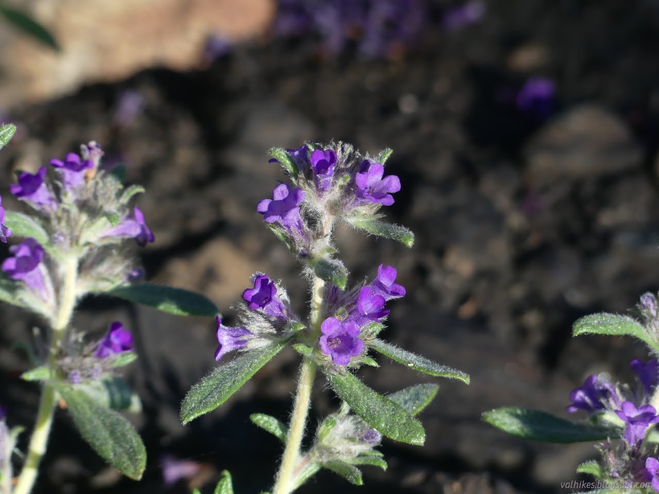
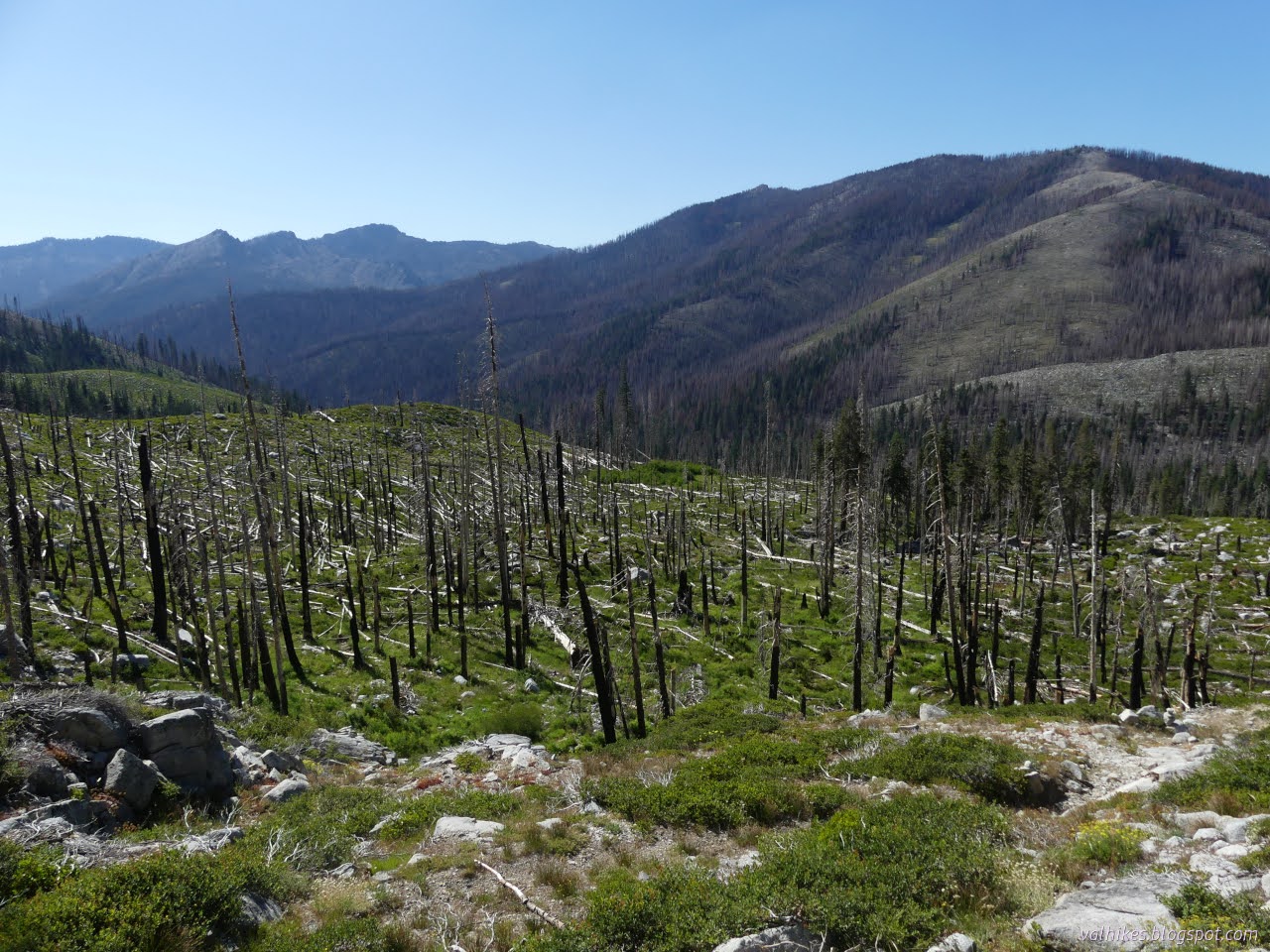
I had given up on finding trail and just took an easy way up to the ridge, coming up much higher than the saddle where the trail supposedly comes through. That high forest was absolutely devastated. Black sticks stand (and fall) all over. Purple flowers are plentiful and absolutely nothing else is growing. (And these flowers have apparently been suggested for revegetation of mountains, so perhaps they are not survivors, but seeded in the sterilized soil.)

It had been recommended to avoid Coffee Creek's North Fork and East Fork since they had been "hosed by the fire". Most of this day would be down Saloon Creek and up Granite Creek, both part of the North Fork drainage and situated between it and the East Fork.

I dropped down to where the trail should be crossing the saddle and found not just trail, but footprints. Maybe my neighbors had come up the day before and done a better job of finding the trail. The footprints didn't last long, but some little cairns were stacked. As the trail turns down, it stops looking much like trail. Instead, it is a funny sort of little wash that mysteriously slides along the hill as much as it drops. Then it turns and slides the other direction. It starts off in little switchbacks, but they get longer. I felt confident I was on trail.

At the bottom of the steeper portion of the hill, I hit green. Ferns and dying grasses and a pair of medium cairns to mark the spot to start climbing for those going the other way. Which way do I go? I followed the gully, but now it was starting to grow. It gets too deep and narrow to walk in. I found more cairns and spotted more generally going this way as I generally followed the gully, then transferred over to more gully along cairns. I was following my digital map line from the Forest Service topo as much as what was on the ground.

I started to get into huge patches of flowers. Checker-mallow was scattered in the great meadows, but along the possible trail were great patches of invasives.


As I got closer to Saloon Creek, I started to pick up an actual trail through the former trees. It has some problems at first, but it is largely there. I was still taking hints from the electronics.

Three cairns near the crossing of the East Fork Saloon Creek mark the junction for trail connecting back to the PCT. Although there was little visible of that trail, the trail below seemed a little better with more traffic. The trail takes this moment to cross the creek and got scruffy on the way down to the water. The crossing is easy here, but how will the return be?


Trail was super easy to follow after joining with North Fork Coffee Creek Trail. An island of trees at the confluence remained with their undergrowth and sticks and everything else. The creek crossing was getting to the limit of what can be crossed on rocks, but there were a lot of rocks available to try on. I wet a sock with one misstep on the way.

I was happy things would be clear to the junction, then climbed back up into burn and weather damage from recent big storms. Bits of trail were washed out, others weren't competing well with the game trails. I ended up following one nice game trail high above where the trail is marked.

I spotted the footbridge for North Fork Coffee Creek Trail through the trees and it looked in good shape, then turned my attention to finding the Granite Creek Trail already in progress. A faint path and a blaze lead to a cut log and a nicer blaze and I was on my way up again. Everything was still a burned and ravaged mess.


A quarter mile short of where it is marked, I met the water of a tributary. Trail was easy to find as it traverses slants, a bit harder across flats, and useless to try at the tributary. I marveled at the stacks of logs jammed up against the trees high on its sides. It probably washed away any trail sign for a wide swath around where the water now flowed sedately along. Beautiful and clear in all the black, I grabbed some water for the rest of the hike as what I had was low.


I came upon the next tributaries about a quarter mile early, too, so maybe that wasn't just it changing course and instead a systematic error.


Approaching the first named tributary, Schuler Gulch, there were actual green trees and something I hadn't noticed was missing: bird song. It was the squawking of Steller's jays, but it brought home how there hadn't been twittering or rustling or even knocking of a woodpecker. Even a burned forest usually supports a few birds and this one was full of fat caterpillars.

Onward I went. I never would have noticed the junction were it not for the fresh sign nailed to a tree to alert me. Actually, I still missed the junction. I looked really hard, but could not find the start of the Doe Lake Trail, which was my next challenge. I poked my way along and found a bit of trail forming up as it launched into small switchbacks down the side of Wolford Gulch.


The nice, big rocks made an easy crossing of Wolford Gulch. On the far side, trail wasn't particularly evident. With hints from the GPS, I found a track. With frequent cairns, I almost was able to keep to it. Someone really wants this trail to stay marked, but it takes a very tall cairn to be visible in the tall grass. Things were pretty good until after crossing Granite Creek to start toward Granite Lake.

After the crossing, I tried to get around some thick alders by going up a gully that was entirely the wrong gully. Returning, I found there was a perfectly good cut through the trees if I just put my faith in the cairns. Then I wanted to follow the perennial stream, or so the map says. I couldn't sort out which small gully on the flat it should be, but they were all dry. The cairns had gone spare too. I gave up on it and crossed the flat and started to climb, figuring whatever trail there was wouldn't be any easier. Once climbing more steeply to the lake, it sure got harder. Then I finally popped out onto some really nice trail which definitely was a whole lot easier.


Granite Lake was my planned destination for the day with a caveat that I might continue on to Doe Lake. I needed water again, so was definitely stopping long enough to get some. The map implies there's none between the lakes. Without knowing the state of the trail in between, I couldn't know if there was enough time to continue. I dithered a bit.

I decided to stay. I dropped my pack and grabbed water gathering and then fought my way along the trail to the other end of the lake where there should be some input. I kicked a lot of sticks and pushed a few logs and generally made it a nicer trail, but there's still one difficult under and impossible over log on the way. It was a little nicer on the way back with my bag of cold camp water and would be a little nicer still for the struggle with the backpack in the morning.
same trip, next day ⇒
*even more photos in the album*
©2023 Valerie Norton
Written 29 Aug 2023
Liked this? Interesting? Click the three bars at the top left for the menu to read more or subscribe!


Comments