Boundary Trail and Big Butte
Six Rivers National Forest
Mendocino National Forest
Arcata Field Office BLM
(map link)
I had moved down the road to find a nice camping area and found myself at the trailhead for Boundary Trail. It wasn't on my mapped itinerary. It wasn't even on the extra stuff I've been thinking about but don't intend to hike that also got into my itinerary. However, I had been thinking about it when I first thought about visiting Yolla Bolly-Middle Eel Wilderness years ago, before the burn. This might have been my entry point for an epic loop, but the fact that the trails after Boundary Trail were not included on the Forest Service topo maps made me reconsider and it never happened. I'd had three biggish hikes and now this mysterious trail was available to me with no further effort. And do you know, I've never been to Mendocino National Forest before? At least not as an adult. I decided on doing a little hike just out to the mysterious "Mon. 128" about 1.5 miles south on this trail that follows the boundary between Six Rivers and Mendocino National Forests.

I packed up loads of water because why not? Besides, I drank a lot of water in a short time the day before coming up Red Mountain. I packed up loads of food because I didn't care to think about what specific things I might want from the normal lunch bag on this short hike. Then I walked past a burned signpost that helped explain why there is virtually no signage on these roads. This is still part of the Hopkins Fire 2020, but I would get into the Doe Fire 2020, another part of the August Fire Complex. Practically all of Mendocino National Forest is under some part of the footprint of this complex.
The trailhead is marked by a trail register. I opened the lid to find a single sheet of paper with no headings for columns, but an entry from October had faithfully filled in hometown, number of people, nuber of stock, day in, day out, and a comment. It was followed by an entry from the week before and then blank lines. It represented a total of 3 people using the trail in the last 6 months. Beyond it was a trail that looks to have gotten a little more traffic than that.


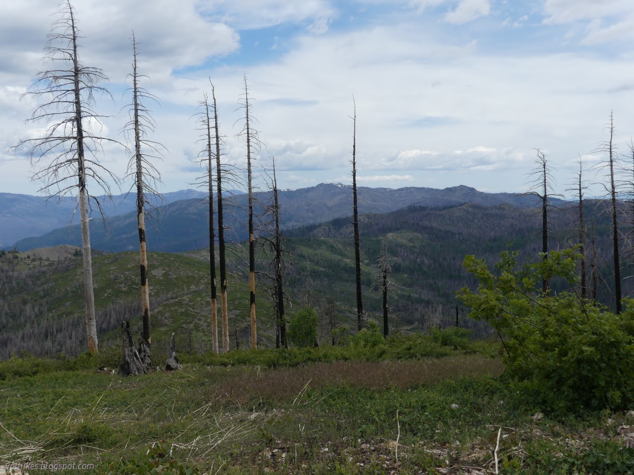
A faint, wispy blanket of cloud was conspiring to keep things cooler than the previous day. I walked along, struck by the barren hills to my right and the trees to my left and the fact that a bit more than expected was growing on the ridge top. There were even shooting stars (gone to seed) and columbines, which can indicate water below the surface.


Close to the mysterious monument, the trail bulges out to the east instead of staying on the ridge. I followed some much smaller trail up instead.

The place I was looking for turned out to be a point separated to the west of the main ridge line.

Unfortunately, it was entirely unadorned with monuments, mysterious or otherwise. There are some lighter rocks that likely show recent breakage of the rocks at the top, whatever "recent" might mean for this particular sort of rock.

So that was disappointing. I had been expecting a marker for the boundary between forests, but realized it is in the wrong place for that. I consoled myself with the extensive view and decided that since the clouds were being so nice and keeping it cool, I'd go ahead and finish off the Boundary Trail. It continues a bit further along the ridge, then finishes up at a junction just past a camping area. It's not very long, so I turned to meet the trail again as it came back to the ridge and continued south.


I got worried people were following the ridge too far and made a way down only to find the trail coming back from "too far" below. Then I waded through some knee high oaks that showed trail well as the long lasting break. However, as the trail was supposed to turn left off the ridge to get to Butte Camp, it actually turned right. I pondered it, and decided to see how far it might get. After all, I had plenty of water and food.

I soon passed a little stream with good flow. The trail was getting use by bear and people and pretty obvious as it went. Sometimes it even looked built. I passed by something that looked a bit like it could be a trail marker, then it climbed steeply and met an overgrown road.


Once up on the old road, the trail was even easier to follow. It has been washed out a bit at the couple of crevices where water can flow, but these weren't too difficult to navigate nor overgrown. I ended up walking about a mile along it.


The trail and road were still going strong when I decided to turn around. I was feeling it was too low to do anything but head off along Round Mountain, but now I'm not so sure. It might go right over the top of Round Mountain and I could have easily added that into the day's final peak total. It wasn't a bad peak total without. I had decided that what I really wanted to do was stop by the water to make sure I had enough in case it turns hot, then head up Little Butte and maybe even Big Butte. In fact, Big Butte is marked with "Mon 132", so there was another chance to find out the identity of these mystery monuments. Having made the plan, I executed it.
However, I did pause by that odd "trail marker" on the way back. I got to thinking that the only time I've seen that much bark removed on a tree for a blaze was when it was a bearing tree. The little metal might have once been a bearing tree poster added because paint on a stripped tree doesn't last very long. The bit of metal once had 5 nails in it and hung from the one remaining in the bottom right corner. It had somehow popped out from all the rest, including the one in the middle showing the corner location in the township, tearing only the top left. It wasn't actually going to help find the marker, but from the map I estimated that it would be somewhere up the hill within 100 feet. I almost tripped over it at 10 feet. It's a closing corner and also happens to mark the boundary between Forest Service and Bureau of Land Management lands.


I got water and shortly after, started up the side of Little Butte. It had looked a bit full of vegetation right at the saddle, so I went before then. There are a lot of choices for route.


Wandering over to Big Butte from Little Butte looked alright, so I launched myself over the side and started doing just that. The slope down is almost bare except for the frequent wildflowers. The slope off the little bump below it is a cliff, so I had to backtrack and find a better way to the saddle and up again.


The walk up the other side was a little harder because there was a lot more vegetation on the vaguely north facing slope. Most of that was ankle high ceanothus of the local whitethorn/buckthorn variety, which is to say very stabby and very short. I could walk across it when required. The rest of the difficulty was fallen trees, but they haven't started falling in numbers yet.

Then I came upon a rocky section, and that was something special. There was a particularly big patch of purple-pink flowers that looked a bit familiar. But of course, Lewisia! Always a sign of a good day. Then it was fritillaries that were a bit earlier in their bloom than the ones full of big seed pods the day before.


I found the benchmark pretty quickly. There was a station and two references left by the Army Corp of Engineers in 1943. There were also some nails in a couple sizes. Besides that, there was a bit of view not too obscured by fire killed trees.


Rain was visible out in the spaces in the distance and a few rumbles rolled around. It was late for staying on top very long anyway. I briefly considered going down and trying the trail I could sort of see below, but it was getting a bit late for adding those miles of questionable trail. It is shorter and a known quantity of difficult the way I came. It was already starting to rain on me when I started down. Unfortunately, I had swapped out the rain coat for a wind breaker when there was no more rain in the forecast. Luckily, very little of the rain had any determination to get anything wet.


The rumbling was finished by the time I got to the saddle between the peaks. The rain was worst for the rest of the way down to the mystery trail. Once back to Boundary Trail, I finally went looking for the very last bit. The trail is probably the flat line of rocky dirt capturing the little stream that flows when it rains. There wasn't a lot obvious about it, but some of it was there. Butte Camp is a large meadow with little signs of camping, but plenty of sloped space. I couldn't find any junction beyond.

And then I headed back. This time I properly followed the trail up onto the ridge and out along its bare top as the last few raindrops fell and mists rose from creases in the land.


I battled with the lupines trying not to get too soaked from the knees down. They were still holding onto a lot of water with their leaves. I tagged Mikes Rock just before finishing, if it really is Mikes Rock. Earlier maps mark the taller point to the east with that moniker.


So that's how I got to hiking a bit over 12 miles when only planning 3. Having gotten back a bit later than expected, I set camp back up. It was flat and quiet and who could ask for more? Maybe a less burned view. Still, I think I would like to try more of the trails and return to Big Butte a little earlier in the growing season. It had a huge patch of fawn lilies in seed and more fritillaries. (The flower kind, not the butterfly.)
*even more photos in the album*
©2023 Valerie Norton
Written 8 Jul 2023
Liked this? Interesting? Click the three bars at the top left for the menu to read more or subscribe!


Comments