Arch Canyon
Bears Ears National Monument
Click for map.
I'm wanting to see the namesakes of Arch Canyon. There's three of them, but they're up some 8 miles of road that is unlikely to let a Scion pass. For example, the start comes off a road crossing a creek, the creek is about road width, and there's even a "designated route" pointing directly down the creek, and just far enough down to be hidden are a sign and register to confirm that, yes, that is the road. Going directly down the creek.

At least it does get out of the creek and stay out of it for the most part. Still plenty of crossings, and look at all the water! Such lovely water! I'm not sure if that's because I'm now hiking in a better area for water or that the 13°F night has got the cottonwoods to shut down entirely for the winter leaving much more water available to everyone else. They certainly were shocked and are now dropping green leaves in some places. These look like they were starting to get ready while the nights were still only getting down to 30°F.

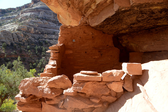
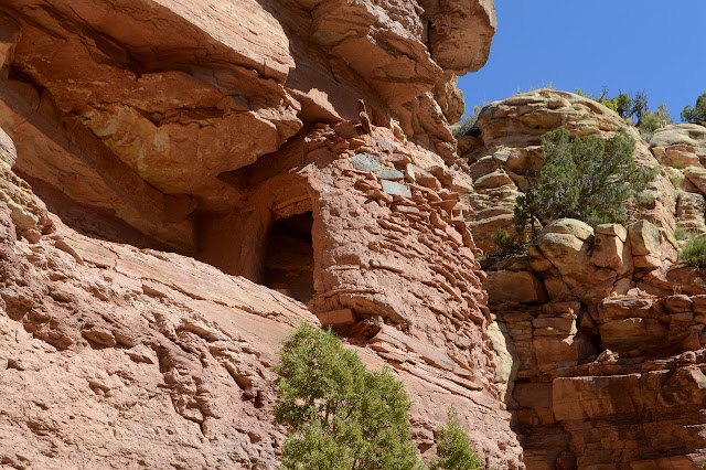
There are some ruins early on. The signs listing developed areas that will continue to be free after the new year have an "Arch Canyon" site. I'm not sure what they mean as this does not seem accessible except by a rather primitive road, but it does have a large sign and fencing to control entry and be sure cows aren't coming up to give the walls a rub. Otherwise, it's a much more open site than I have seen set at the bottom of a cliff with only a slight bulge for an overhang. The cliff backing contains petroglyphs and pictographs of some delightful, but hard to see, designs.

There is a tall grass all around that reminds me of the corn patch my dad generally planted in summer. It's the right height but hasn't got anything like ears below. It's rather unlikely it's a descendant of the corn that was farmed here, just a tall grass. Tule maybe? Now I've gone and forgotten what tule should look like. The road is sandy and takes anything but a direct path up the canyon. There are footprints in it from others walking before me and according to the register they might as well stop the motorized traffic. This road gets lots of walkers.


The creek bed is sandy too and the water vanishes and returns as I go. The road is so hard to walk along with all its sand that I try the rocky creek for a little way. Besides, even with its own meanders, it seems a little more direct than the road. Meanwhile the canyon shows off its infinite variety in the ways that sandstone can be carved.


I'm at a junction with a large tributary when the second ATV rolls by. Today only ATVs brave the road, at least among things with a motor. I'm thinking maybe I'll go somewhere they can't go as I turn away from the road and start up the wash that is almost as big.


But then I'm thinking I want to go off to see something completely different. There is a promise of just such a thing if I go back and then a little further north. So I turn back, again after about four miles. Maybe a little less today. There is still one last thing to check out before leaving the canyon completely.


There were more ruins to be seen than just the ones at the mouth of the canyon. These tended to be within alcoves, but sometimes flush with very narrow ledges. Those looked like they might be camouflaged.

©2019 Valerie Norton
Written 19 Nov 2019
Liked this? Interesting? Click the three bars at the top left for the menu to read more or subscribe!


Comments