Buckeye Peak
San Isabel National Forest
White River National Forest
(map link)
In my post about Galena Mountain, I mentioned there were two very lone geocaches in the area. The second, not signed since 2015, rested south of Buckeye Peak, another peak with 1000 feet of prominence rising above Leadville. It looks like the common route to bag this peak is also from the south. I didn't much like that route because of the 4x4 access road. I decided to come at it from the north from Ski Cooper, then a bit of roughly following the Continental Divide, which serves as county line and forest line along there. To get the geocache, I'd continue over the top, then finish with a little more cross country to find a road that connects back to Ski Cooper.

I parked off to the side and started up Cooper Hill. There were a couple rough roads (authorized vehicles only) to choose from. I didn't quite follow either since there are a couple more geocaches on this hill to distract me from a sensible route. (Found them both: GC25M70 "Chapati" and GC25M6C "Brioche".) Then I tagged near the top of Cooper Hill even though it really isn't a very impressive peak. The top seems to be the built up base of the massive ski lift anchor.

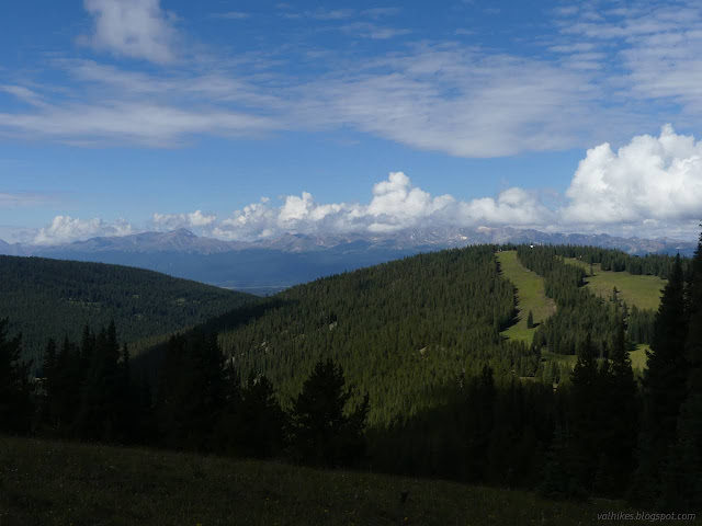
Ski runs go every which way from the top, except southeast because that's out of bounds. I picked a rough road to follow down and toward the peak, decided it was the wrong one and skootched over to another road.


From the saddle, the road I was following got steadily fainter. I hadn't expected there to be any at all. Up the hill, I encountered the disassembled pieces of snow fencing, so perhaps it is a service route for those. I just sort of followed the ridge upward. It gets a little steep in places, but for the most part it was a delightful walk in the alpine tundra.

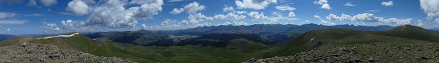
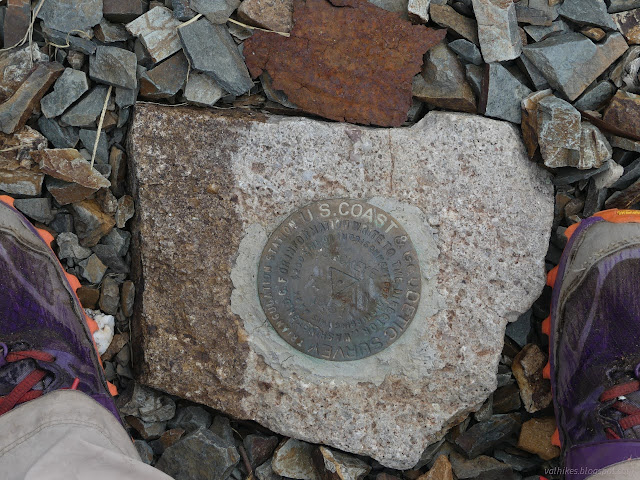
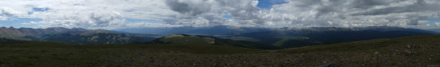
I hit the Chicago Ridge and it looked like surveyors had hit it before me. I had hope of some county line markers. I've only ever found a few of those and never in Colorado. No such luck. They didn't leave any benchmarks.

It was tempting to head north briefly to hit the high point of Chicago Ridge, which is only 14 feet higher than where I was already. Unfortunately, I had expected afternoon showers to contend with. The loop is only about 10 miles long, but I didn't want to take too much extra time before getting to the peak.

So I turned south toward Buckeye. There's a fair bit of up and down and sometimes some rocky steep spots. The first was the south side of that first little peak I'd been standing on. There was just one big peak between me and Buckeye.


There were more of those markers at I went. I left the boundary and divide at the first peak, where I started to see remnants of some old trail instead. There were posts in cairns and tread and I could even make out the first of a switchback, maybe two, heading down the south side of an east going ridge. It got really obvious on the north side of Buckeye where the rocks have been cleared for a nice tread.


And so I came to the top of Buckeye Peak.


I headed down. It's rather steep in places, especially just above the lonely geocache, GC1WD1M "Birdseye of Buckeye". I met a pair of hikers coming up. Three more were having lunch within 100 feet of the geocache. It overlooks Buckeye Lake where no fewer than 5 fisherfolk were trying their luck with the line, and where the description suggests you come up from. Another group of 3 got caught nearby driving their ATV where it is extremely explicitly not allowed. There was an absolute crowd of people around this geocache that was in pristine condition but really hadn't been signed since 2015. At least it has seen a couple more people in its life than the other one had. I was the fifth signer instead of the second.


And after taking a time to enjoy the spot just as so many others obviously do, I turned and headed into the most difficult navigation of the day to get to a road that is marked as both paved and 4x4 via the valley to the west. Had I not had the geocache to find, I'd have stayed up on the ridge for a while, but I'm not sure that would have been the right choice. The grassy valley was much easier walking at first. I passed two prospects on the way that I wouldn't have recognized as such had they not been marked on the map.

However, I then got the choice of rocky or willowy. The rocky wasn't so hard as long as I avoided the raspberries. They were easily avoidable. Then I got to the trees. I found little game paths in them and once a single ribbon. Then I found a larger trail that was only sort of going my way, but also for the creek and I needed water. So I followed that to the crossing.

I had thought my prospects looked better on the north side of the stream, but the trail looked so solid, I decided to try my chances on the south side. I crossed and the trail vanished. Well, there were three maybes for its route but they all fizzled. So much for that. I continued down on that side, anyway, finding more maybe trails until I found a mine that, while not marked on my map, was big enough to have had rails into it at one time.

After that, I was very expectant of a trail, but could only find about half of it. There were random prospects on either side of the stream and finally a dilapidated log cabin. Just before the cabin, I'd found old road, but it vanished into a meadow. The cabin had a driveway nice enough for walking, but on the other side of the stream. I had to find a dry way across the meadow first.


I found a way and got a closer look at the cabin before following its rough driveway down. I found the 4x4 road and it had definitely never been paved, so life made a bit more sense than the map. All I had left was to follow it to a junction and hang a left, then keep going.


I got one last, desperate view of the mountain behind me and then was deep in trees. There are more mines marked on the map, but they looked like they'd be rather difficult to check out. I came upon yurts in the trees. These seem to be rentals offered by Ski Cooper. There's an ATV that will take you, or at least your gear, out to the place. At that point, the only views are those found in logged areas that are now meadow.


It got to raining before I finished, but not very hard. I got confused how to go since most of the road headed off to service area for the ski lodge. Then I found a bit of trail to follow instead, which kept to some less industrial looking areas. An excellent loop, although the finish had some dreary moments.
*photo album*
©2022 Valerie Norton
Written 22 Sep 2022
Liked this? Interesting? Click the three bars at the top left for the menu to read more or subscribe!


Comments