Zirkel: Main Fork Encampment River and Stump Park
Medicine Bow-Routt National Forest
(orange line, map link)
DAY 1 | DAY 2 | DAY 3
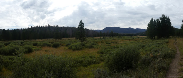
I settled on a three day loop plan to see a bit of the Encampment River at the north end of Mount Zirkel Wilderness with an excursion up Davis Peak for a bit of variety of terrain as well as visits to a few lakes. I thought about including some of the Continental Divide Trail, but the odd fat dotted line it follows turns out to mean ATV trail (on the western edge of the wilderness). Pass. I swapped out the Exped Ultra 5R for the Big Agnes AXL Insulated, so camp will look very similar to the picture a couple days ago except the mat matches the bivy instead of the roof. It saves half a pound and if I can't use that "3 season" thing in August, when can I use it? The Encampment River Trailhead might be the only one in Colorado you're allowed to camp at, or maybe someone's just removed the sign. There's a large loop with a few spots and a corral in the middle and a toilet too. Maybe it's because you have to get there from Wyoming and you're already on (technically, but fine for the Scion) 4x4 road by the time you cross to Colorado. It also has an information board with map and Colorado branded "Bury your poop! Pack it in, Pack it out! That includes your toilet paper!" messages. The map has three lakes in the middle circled in red, meaning no camping within ¼ mile. Thank you for telling me before I get there at the end of the day! Seven Lakes and Gem Lake weren't included, so no changes to plans were needed.

It's about a mile of flat walking to the junction where my loop starts. There's some wilderness rules just before the junction and finally wilderness just after, right after the river crossing. My hope for a bridge went unfulfilled and I didn't want to start off with wet shoes nor did I bring my neoprene socks, so just had to ford it in tender bare feet.


The trail teed off into another trail already in progress. It would be really easy to go the wrong way if headed in the other direction. I blame cows, but maybe it's whatever connects to the Tie Hack Trailhead. Happily, although trail can get a little faint crossing meadows, it's really the only place where there is confusion.


Although I didn't get a bridge for the river, there are short boardwalks along the way. There wasn't always something under them to worry about, but I'm sure they're great when it's rainier.


Then after 5.5 miles of nice trail with only two trees down, I came to a spot where three trees had fallen in a pile across the trail. The top had been removed and the bottom two had the start of cuts. One more tree after these had been removed and that was it, the end of any recent work. I launched myself out over 2 miles of some of the hardest trail I have ever encountered with an obvious tread. The third sawyer beetle I saw may have been squished and squished and squished some more, which didn't make me feel any better because it would help the trees not one jot. There may have even been a shout or two, "Why you gotta kill all the trees?" to any beetles in hearing range. Deer and elk are clearly still using the trail and, with the people, establishing walk around routes for each tree, but it still gets really tiring and frustrating.


There's two more crossings of the river, but in this area there are plenty of big rocks to hop across. I made quick work of the crossings without any worrying about wet shoes.

I made it as far as the Beaver Creek Stump Park Trail. Beaver Creek is over the top of the ridge. Someone had cleared a tree from it by cutting it once and sliding the remains across my trail. There is something of an insult in that. I turned up it toward Stump Park and found things had gotten easier. There were fewer trees and had been some minimal maintenance. Whereas the first bit of maintenance was a determination to clear the trail, this looked like it was getting a clear enough route to get a horse through. Often small trees on walk arounds were cut rather than clearing the trail itself. Admittedly, the trail took a rather direct route uphill and could probably use some more little wiggles in its climb.


I was getting a little overconfident about water. I figured I'd grab a camp site at the western end of Stump Park after finding water at a particular crease in the land. Not that one, that one. And if I didn't, I could just go a short way down from the top, out of my way, and get water from Beaver Creek. I passed a campfire ring just 20 feet off the trail as I approached the water bearing crease which really did have water. Then I headed up into the park, well past that inappropriate camp right next to the trail and found a nicer spot right where I'd figured I would. I had some small trees for wind shelter but was away from the forest and its standing dead. A perfect day although it was already 7PM as I got water and pitched my roof in time to ward off the first drops of the night's rain.


continue to the next day ⇒
*photo album*
©2022 Valerie Norton
Written 6 Nov 2022
Liked this? Interesting? Click the three bars at the top left for the menu to read more or subscribe!


Comments