I meant to have a look at the Great Salt Lake as I drove by, and how could I not? I-80 rides right on top of it for miles. But I came across in the dark in a torrential rain. When the 18 wheelers passed, I couldn't even see the road in the splash. I could smell it. Oh, what a stink. I read about the Salton Sea before I started this trip in February, how it comes and goes and when it goes, it is a ecological disaster as it becomes too salty for the fish that somehow came to it. This seems like at least a little of that stink, which is odd because I thought it was too salty for fish.
So having not seen the lake again, I got up with the first of the light and started heading west across the first stretch of desert with the sun rising in my rearview mirror. I stopped for breakfast at the rest area about ¾ of the way between ranges. (Compare and contrast wandering across most of the desert before breakfast with Mark Train's account of coming across a very similar route in a stagecoach in Roughing It, chapter 18.) It's a good spot to take in Lake Bonneville. The Great Salt Lake used to be far greater and Lake Bonneville is the name given to the most recent ancient lake that sat here. It filled the Great Basin until there was outflow at Red Rock Pass in southeastern Idaho. (Actually, that hadn't been the normal state of things and when it breached the pass, it caused a flood down the Snake River and lowered the lake by 300 feet. Presumably it continued to flow yearly until the lake lowered again.)
Very welcoming! Marking the location (approximately) of "Utah's famed measured mile—site of world land-speed record runs" and a foot wash if you to wandering through it. Only there's no water here anymore. All water was piped 10 miles from Wendover.
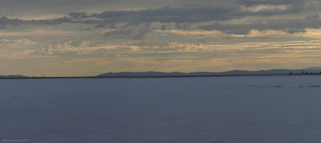
Still cloudy, so not much actual sunrise in the rearview of the line of headlights to the right
Enjoying the "lake" after the night's heavy rains
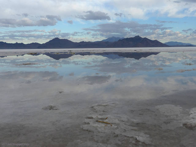
Everything is just flat and salt covered, until it's not
The salt forms into structures
Look to the far mountains and note the horizontal lines that are old lake levels
More delight in the watery desert
*Lake Bonneville photo album*
Klamath National Forest (Map link.) It has been a couple years since I actually did some trail work besides kicking the odd log and a lot of sticks off the path. There have been some excursions by the Siskiyou Mountain Club that got far enough south to tempt me, but none had worked out thus far. I noticed they would be working out of Clear Creek for five days and that sounded long enough to make it worth the drive. Is it odd that these California trails are getting a lot of maintenance by people from Oregon? Yep. I also notice that the folks driving out of Ashland are actually a couple miles closer to the trail than I am. I'm coming from another county too. Judging by the license plates on the way, it looks like more people from Oregon are using these areas too. In fact, you can find it covered in guide books for southern Oregon. Thursday The lower (last) parking area at No Mans Trailhead with the traditional burn area hazards signs marking the trailhead itself. The wo...
Uncompahgre National Forest (map link) The Forest Service seems to be uncertain if it is Lake Hope or Hope Lake, but more certain that it is the Hope Lake Trail. It consistently marks the road up to the trailhead as a 4x4 road, so I parked in a turnout at the bottom and started up, getting increasingly grumpy about how it is a rather good road with a loose rock here or there. I chatted with some campers about how it was probably great all the way up, but they'd gotten to their rather brilliantly picturesque site and been sufficiently mesmerized by it not to continue on. Talking with them got me sufficiently emboldened to actually stick out my thumb at the truck that came by as I finished the chat. When you're going 5 MPH anyway, it's easy to stop, and he did. Greg was going for the hike too and actually wouldn't mind having a buddy. The road promptly turned to something it wouldn't be wise to try the Scion on. With good judgement, I probably could make it, but...
San Diego Sung has been wanting to actually tour the aircraft carrier turned museum down in San Diego and I said sure, so off we go. Of course we start off just attempting to take in the size of the boat. There is something downright comical about the snack bar and tables at the stern and manikin service men eternally hang about on deck. It gets serious quickly going forward. The length of the USS Midway with snack bar at the back.
Gunnison National Forest DAY 1 | DAY 2 | DAY 3 | DAY 4 | DAY 5 | DAY 6 (orange line, map link ) I got an early start trying to beat the mosquitoes and sort of made it. I noticed the missing bit of sign on the ground to finally discover that there's no camping (or campfires) allowed at the lake. I turned at the post, ready to take it wherever it may go. The couple at the lake thought it was silly to think it might rain in the afternoon because the air was just too dry. Indeed, I'd washed two pairs of socks (in a bag well away from the lake and creek because I'm not a barbarian and I know soil bacteria is needed to break up everything from that and you don't find that floating in water) which were very nearly dry in the morning. It was quite pleasant until I got to the long grass meadows and everything from my knees down got wet anyway. A little bit of view over the meadow still shadowed in the morning. The trai...


Comments