Kings: East Fork Smiths Fork and Red Castle Lake
Uinta-Wasatch-Cache National Forest
(pink line, map link)
DAY 1 | DAY 2 | DAY 3 | DAY 4
The High Uintas have been on my list of places to visit for a while. I headed off toward Bridger Lake to stick with the "Bridger" theme, but never quite got there. And what hikes could I do there? Well, the typical approach for Kings Peak, high point of Utah, was just around the corner. It's a sign! On my first big outing, I hiked the high points of New Mexico and Arizona. On this outing, I'd already hiked Colorado's high point. Utah would make it a nice, complete, Four Corners set. (Disclaimer: following "signs" is a good way to make bad decisions.) That usual approach is an out and back without much in the way of on trail looping options. I could make a loop from China Meadows, which is around the corner the other way. The loop I picked would be nice in four days. I settled on the direction that would make climbing Kings Peak fall on the sunny third morning instead of the stormy second afternoon, packed, and got moving.

I found that there is a rather steep fee of $9 for overnight parking at the China Meadows Trailhead, going to an concessionaire. The Forest Service topo shows the trailhead at the end of a road that is truly 4x4, so I retreated to the bridge which has parking on the west side. Unsigned trail starts on the east side of the bridge and is difficult to follow. I suspected I was on cow paths until I came to the decaying boardwalks. Never heard of cows building boardwalks, so it must be official trail after all. I should have gone the other way on the road anyway, since there's no bridge for the trail and the only way across is to wade.

I had my shoes off and crossed barefoot since I didn't want to start off with wet shoes. Poor, tender feet. Walking a little bit of road would have avoided this large water crossing without a bridge. Trail meets up with an old road that I followed to the actual trailhead, marked as more campground on the topo. The iron rangers were all covered in plastic and there was no mention of a fee at both the equestrian and the regular hiker trailhead. I guess there's no fee after all. That first had quite a few trailers and the second at least half full of cars. There were quite a few people out on this trail.

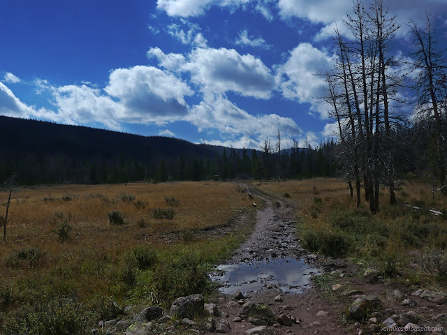
I passed horse riders and hikers as I made my way along the trail, trying to stay out of the mud. There was quite a lot of mud. It had been mildly and heavily raining off and on for a few days.

The trail felt practically flat as I followed the East Fork Smith Fork toward the distant bumps. There's all too many beetle killed trees along the way. Gradually, there were more and more big meadows to go with the bedraggled trees.
I stopped by the first bridge to get some water and watched a kid ride by poking a cloth covered ball into the top of a metal tube. I'd forgotten about musket season. "Hunting season" was still to come for those who only worry about riffle season, but archery season had been going on for a month or so and musket season started a few weeks later. The intermediary skill required for these lighter, lower powered guns seems to be quite popular. Probably a little over half the people I saw were obviously out to hunt.

I passed the Highline "A" (North Slope) Trail, the AllTrails way to make the loop I had planned. It looked well traveled. An unruly pack of pack goats dodged past. They're the first I've seen in the wild other than ones I was hiking with.


Also, the scenery improved. Except the beautiful meadow I parked next to, it wasn't all that great for the first few miles.

I'd mentioned how very flat the trail felt to some coming down and they said there was some good hill in a few miles. I spotted where it used to be a steeper trail, but now it goes up some very easy going switchbacks instead.


I found a pair up to photograph who were bubbling over with how nice it was in the sun as well as how impressive it was the day before when it hailed and sleeted and every other sort of weather you can dream of took its turn to happen. Well, that's what the weather man had said would happen. Good to know he's doing well at the predicting. And it would happen again the next afternoon, so he said.

I was only aiming at the junction near Lower Red Castle Lake for the day. With the trail being so easy, there was time to head up to Red Castle Lake. I'd see a camp on the way, surely.


There wasn't supposed to be weather passing through this afternoon, though. It came, timed to be at its height as I made it to the lake. I reached the top and had to pause to pull on my puffies before looking around.

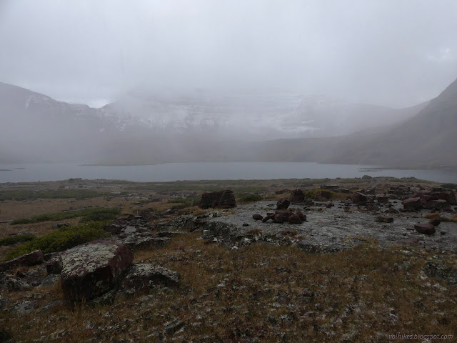
The weather cleared quickly, but I headed back down quicker. I sort of knew it would and the puffies were working, but I missed getting a good look at the lake. Considered going back up, but it was really getting late. I wandered around looking for a good place to camp instead. I'd already spotted one moose on the way up. Now I was very nearly running into them as I failed to find anything I liked.


I decided to abandon that area and try to get north of where Red Castle would be throwing its morning shadow. I powered down the trail and found something suitable for camping just past a creek crossing. It looked just far enough north, maybe. There were still moose nearby, but it had been minutes since I'd seen them. It was just about time for sunset and already getting dark.


I got myself fed and tucked away into my tent. (I did swap the gear back to tent for this trip.) That was an exciting finish to a day that started off easy.
same trip, next day ⇒
*Wasatch 2022 photo album*
©2022 Valerie Norton
Written 24 Nov 2022
Liked this? Interesting? Click the three bars at the top left for the menu to read more or subscribe!


Comments